


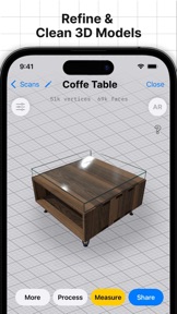


3d Scanner App™ utilizes LIDAR and TrueDepth technology to capture high-quality, full-color 3D models of objects and spaces. It offers professional-grade export capabilities, including raw point clouds and floor plans, designed for integration with GIS and photogrammetry software.
Overview · Full Intel report in progress
The App DNA
What makes this app unique?
For Professionals and hobbyists requiring precise 3D spatial data for architecture, GIS, or photogrammetry workflows.
What does it look like?
Key features
Supports standard 3D formats like USDZ, OBJ, GLTF, and STL, alongside raw point cloud data such as PTS, PCD, and LAS.
Enables geo-referenced data export for GIS tools like ArcGIS and compatibility with photogrammetry suites like Pix4D and Reality Capture.
Provides built-in tools to refine, crop, and perfect 3D scans directly within the application.
Allows users to export scan data as floor plan images in DXF format for architectural documentation.
How much does it cost?
Velocity
Active developmentShow more...
5 versions in history. Development pace: active.
Who built it?
AI Photo Editor Lab SRL
9 apps tracked · Utilities
 Photo Eraser - Remove Objects
 Tape Measure®
 Pocketbooth Photo Booth
 Sweet Home 3D: Plan Your House
 LUMINS - Light Photo Editor
 Sweet Home 3D Plan Your House
 Blurry Photo Aрр
 Sweet Home 3D: Plan your house
User Sentiment
What do users think recently?
How are ratings & reviews evolving?
Not enough recent reviews to extract reliable themes yet.
Read the full review analysisCompetition
Competitive landscape for 3d Scanner App™
How's the Utilities market?
The rivals identified
The Analyst's Read
Key takeaways for 3d Scanner App™
Where is it heading?
Bottom line
While the app offers robust technical export features for professional workflows, recent user feedback indicates significant dissatisfaction regarding the transition to a restrictive monetization model.
Report last updated