


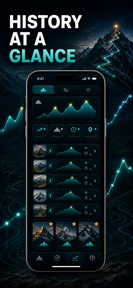


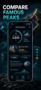
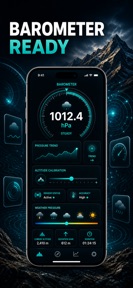

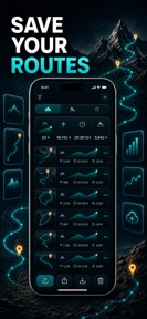
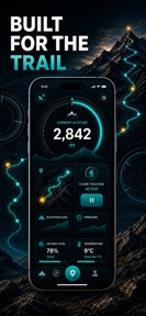
Altimeter: GPS Elevation is a utility app for iOS that provides real-time barometric altitude and oxygen level tracking for outdoor activities.
The App DNA
What makes this app unique?
The app removes the reliance on cellular or GPS signals for elevation tracking, serving users who operate in remote backcountry environments where connectivity is unavailable.
For Outdoor enthusiasts including hikers, mountaineers, cyclists, and drone pilots who require reliable elevation data in remote environments.
What does it look like?
Key features
Reads live altitude and air pressure using the device's built-in barometer, functioning without cellular or GPS signal.
Captures gain, peak, ascent, descent, and range data during hikes or climbs, generating elevation profiles.
Calculates estimated oxygen levels based on current elevation to assist in gauging air density.
How much does it cost?
The freemium model gates historical session data and export functionality behind a subscription, while keeping core sensor readings free to maximize user acquisition.
Velocity
Maintenance developmentperformanceopaqueShow more...
With only one release in the analyzed window and a last update occurring 22 days ago, the development momentum is classified as maintenance. The latest release provides no new features, focusing exclusively on generic stability and performance improvements. The publisher maintains a low-frequency update schedule, suggesting a focus on long-term stability rather than active feature expansion or live operations.
Who built it?
Phuc Pham
13+ apps tracked · Utilities
 Gym Workout Planner & Log
 Book Journal & Reading Tracker
 3D Weather: Isometric Forecast
 Colour Time Block Day Planner
 Birth Log: Midwife OBGYN
 Calculadora Ratio Café
 Step Counter & Pedometer Walk
 Identificar Rocas & Piedra
 Restaurant Food Diary Log
 JSONViewer: JSON Tool
 Sparziel: Spardose Sparplan
 Talking Alarm Clock Briefing
User Sentiment
What do users think recently?
How are ratings & reviews evolving?
Not enough recent reviews to extract reliable themes yet.
Read the full review analysisCompetition
Competitive landscape for Altimeter: GPS Elevation
How's the Utilities market?
Altimeter: GPS Elevation operates in the Utilities category with a focus on hardware-level sensor utility. The app currently holds a 0-star rating with no reviews, indicating a lack of market penetration since its June 2026 release.
Read the market outlookThe rivals identified
Unlock the deeper market read.
Access the full report for freeThe Analyst's Read
Key takeaways for Altimeter: GPS Elevation
Where is it heading?
The outdoor utility market is consolidating around apps that offer integrated navigation and social features. Altimeter: GPS Elevation remains exposed due to its limited feature set, and the PM must decide whether to expand into navigation or double down on sensor-specific utility to avoid obsolescence.
- The app remains in maintenance mode with no major feature updates, suggesting a focus on stability over rapid market expansion.
The SWOT
- Barometric sensor integration enables offline altitude tracking in remote environments
- Localized pricing in high-altitude tourism markets could capture users
Next best moves
Ship offline map caching because the current barometer-only focus limits utility in navigation-heavy scenarios → increase session retention
The counter-intuitive read
The lack of social features is not a…
Read the full takeSince the last report: Market positioning now reflects a lack of user adoption since the June 2026 launch, while the SWOT analysis has been updated to include specific competitive threats and localized pricing opportunities.
Bottom line
Altimeter: GPS Elevation maintains a clear utility-first position by prioritizing hardware-level sensor access over complex social features, and the PM should focus on refining the offline recording stability to defend this niche against broader navigation competitors.
Unlock 1 critical friction, 1 market threat and the analyst’s take.
Access the full report for freeFAQ
Does Altimeter: GPS Elevation require an internet connection?
Is Altimeter: GPS Elevation free to use?
How does Altimeter: GPS Elevation compare to the built-in Compass app?
Sources
- [1] App Store, source
Report last updated