



Cadastral reference to GPS is a utility app for real estate and agricultural professionals that converts land parcel references into GPS coordinates on iOS.
The App DNA
What makes this app unique?
It removes the time-consuming friction of navigating multiple, non-standardized government cadastre portals to locate specific plots of land.
For Real estate agents, surveyors, architects, and agricultural professionals requiring precise land parcel data and mapping integration.
What does it look like?
Key features
Translates official cadastral references into WGS84 coordinates and vice versa, replacing manual navigation of government portals.
Provides solar potential, market valuation, and NDVI data, gated behind a €4.99/month subscription or €14.99 per report.
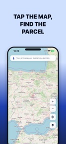
Enables users to tap parcels directly on a map to retrieve data without manual entry.
How much does it cost?
The freemium model uses a daily search limit to drive conversion to Pro for professional users requiring unlimited access and parcel intelligence.
Velocity
Active developmentperformanceopaqueShow more...
The app maintains an active development cadence, shipping 2 releases within the observed window. Despite the frequent updates, the release notes are consistently opaque, providing no insight into specific feature additions or functional changes. This pattern suggests the developer may be utilizing server-side feature flags or A/B testing rather than traditional App Store feature deployments. The development trend is stable, focusing exclusively on internal stability and performance maintenance.
Who built it?
User Sentiment
What do users think recently?
How are ratings & reviews evolving?
Not enough recent reviews to extract reliable themes yet.
Read the full review analysisCompetition
Competitive landscape for Cadastral reference to GPS
How's the Utilities market?
Cadastral reference to GPS occupies a niche utility segment, providing specialized land-data access that generic mapping apps lack. The current pricing structure targets high-intent professional users who derive direct financial value from time saved during field visits.
Read the market outlookThe rivals identified
Unlock the deeper market read.
Access the full report for freeThe Analyst's Read
Key takeaways for Cadastral reference to GPS
Where is it heading?
The market for specialized land-data utilities is consolidating around apps that offer direct integration with official government databases. Cadastral reference to GPS remains well-positioned, but must prioritize offline functionality to maintain its value proposition for field-based professionals.
- The consistent release cadence indicates a stable maintenance phase rather than rapid feature expansion, ensuring core utility remains functional.
The SWOT
- Direct integration with official European cadastre databases provides a defensible data accuracy advantage
- Expanding coverage to additional European countries would increase the addressable market
Next best moves
Ship offline map caching because field-based users report connectivity issues in rural areas → increase session reliability
The counter-intuitive read
The reliance on official government data is a strength, not a weakness…
Read the full takeSince the last report: The developer has pivoted its strategic narrative to frame official database integration as a competitive barrier to entry, while maintaining a stable feature set focused on professional utility.
Bottom line
Cadastral reference to GPS provides a high-utility service for land professionals, but the reliance on external government data sources requires a focus on offline reliability to ensure consistent value in remote field environments.
Unlock 1 critical friction, 1 market threat and the analyst’s take.
Access the full report for freeFAQ
Is Cadastral reference to GPS suitable for professional surveyors?
How does this compare to using free government cadastre portals?
Does the app work in rural areas without internet access?
Are there free alternatives for locating land parcels?
Sources
- [1] App Store, source
Report last updated