


Civil Field Photos


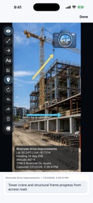
Civil Field Photos is a field-first photo documentation app for civil construction, providing GPS-stamped imagery and project organization on iOS.
The App DNA
What makes this app unique?
The app removes the connectivity dependency and account-creation friction that typically delay documentation in remote construction environments.
For Civil engineers, surveyors, and construction managers requiring field-based photo documentation.
What does it look like?
Key features
Stamps coordinates, heading, and altitude onto images.
Groups photos into projects with custom tags.
Captures and stores all data locally without network connection.
How much does it cost?
The freemium model uses a single-project limit to drive initial adoption, while gating multi-project management and branding behind a subscription.
Velocity
Maintenance developmentopaqueShow more...
Civil Field Photos exhibits a maintenance-level cadence, with only one release recorded in the analyzed window. The latest version did not introduce functional changes, focusing instead on metadata updates. Development appears stagnant, as no new features or performance improvements have been deployed in the last 27 days. Future updates remain infrequent at this current pace.
Who built it?
User Sentiment
What do users think recently?
How are ratings & reviews evolving?
Not enough recent reviews to extract reliable themes yet.
Read the full review analysisCompetition
Competitive landscape for Civil Field Photos
How's the Productivity market?
Civil Field Photos occupies the niche for offline-first construction documentation on iOS. The lack of a free-tier multi-project limit forces a clear choice between casual use and professional subscription adoption.
Read the market outlookThe rivals identified
Unlock the deeper market read.
Access the full report for freeThe Analyst's Read
Key takeaways for Civil Field Photos
Where is it heading?
The construction documentation market is shifting toward integrated project management, placing pressure on single-utility tools like Civil Field Photos. The app's future depends on its ability to transition from a solo-capture tool to a team-based platform before larger competitors integrate similar GPS-stamping features.
- The app is currently in a maintenance phase, with the latest release limited to store listing refinements.
- The offline-first design creates a specific utility for remote sites that cloud-dependent rivals cannot serve.
The SWOT
- Offline-first architecture removes connectivity barriers in remote construction sites
- GPS-stamped metadata creates a defensible record-keeping standard for professional users
- Expanding KMZ export capabilities could capture share from desktop-heavy GIS tools
- Adding team-based project sharing could unlock B2B enterprise adoption
Next best moves
Audit Pro conversion funnel because the $59.99/year price point is high for a single-utility tool → increase subscriber acquisition
+ 1 more prioritized moveThe counter-intuitive read
The app's lack of cloud sync is not…
Read the full takeBottom line
Civil Field Photos' offline-first utility provides a clear value proposition for site work, but the Pro tier pricing requires demonstrating consistent time-savings to justify the annual cost.
Unlock 2 critical frictions, 2 market threats, 1 more prioritized move and the analyst’s take.
Access the full report for freeFAQ
Is Civil Field Photos free to use?
Does Civil Field Photos require an internet connection?
What formats can I export my reports in?
Sources
- [1] App Store listing
Report last updated