




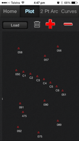
Cogo Surveying is a coordinate geometry and leveling utility for professional surveyors on iOS.
The App DNA
What makes this app unique?
The app removes the friction of manual field calculations by centralizing point data and automating traverse and inverse computations, which saves time on site.
For Professional surveyors and field technicians requiring mobile tools for coordinate geometry and leveling calculations.
What does it look like?
Key features
Imports .cogo files or manual point entry for use across calculation modules; centralizes project data to drive retention.
Calculates elevations from level run readings with direct .csv export; reduces manual error and time-on-site.
Calculates coordinates by intersecting lines or projecting lines when no intersection exists; serves as a primary driver for professional acquisition.
How much does it cost?
Single-tier paid model at $5.99, targeting professional surveyors seeking a low-cost mobile alternative to dedicated hardware.
Velocity
Dormant developmentnew contentShow more...
Cogo Surveying has been inactive for 3,574 days, indicating the project is no longer receiving development support. With only one version recorded in the analyzed window and no updates for nearly a decade, the app has reached a zombie state. There is no evidence of ongoing maintenance, feature expansion, or operational activity.
Who built it?
User Sentiment
What do users think recently?
How are ratings & reviews evolving?
Not enough recent reviews to extract reliable themes yet.
Read the full review analysisCompetition
Competitive landscape for Cogo Surveying
How's the Utilities market?
Cogo Surveying holds a niche position in the Utilities category, relying on a $5.99 one-time purchase model. The lack of updates for 117 months limits its ability to compete with modern, cloud-integrated surveying tools.
Read the market outlookThe rivals identified

By Land Analysis Lab
Land Survey targets the same land measurement audience as Cogo Surveying by offering map-based area and distance calculations instead of manual coordinate-based surveying.
- Land Survey uses Google Maps for visual point placement, whereas Cogo Surveying requires manual coordinate entry.
- Land Survey supports over 30 area and distance units, while Cogo Surveying focuses on coordinate geometry calculations.
- Land Survey is free to download, while Cogo Surveying requires a 5.99 purchase.
Unlock the head-to-head verdict: where this rival wins, and where it loses.
Access the full report for freeThe Analyst's Read
Key takeaways for Cogo Surveying
Where is it heading?
The surveying utility market is consolidating around cloud-native, GIS-integrated platforms that offer real-time data portability. Cogo Surveying's lack of development activity leaves it exposed to these modern rivals, which will likely capture the professional user base as legacy hardware-replacement tools become obsolete.
- The 117-month update gap indicates the app is in maintenance mode, which erodes trust for professional users requiring modern data security.
The SWOT
- Points database creates a data-lock mechanism that increases switching costs for professional users.
- Localized pricing could be explored in high-ARPU markets where professional surveying tools remain expensive.
Next best moves
Audit current codebase for OS compatibility because the app has not been updated since 2016 → prevent total failure on modern iOS versions.
The counter-intuitive read
The app's lack of cloud integration is a…
Read the full takeFeature gaps
Cloud storage and syncing (available in Field Area Measure but missing here) +1
Since the last report: The application remains in a state of total inactivity, with no material changes to features, pricing, or competitive positioning since the previous report.
Bottom line
Cogo Surveying remains a functional utility for coordinate geometry, but the lack of updates since 2016 creates a significant technical-debt risk that will eventually erode its professional utility.
Unlock 1 critical friction, 1 market threat and the analyst’s take.
Access the full report for freeFAQ
Is Cogo Surveying suitable for professional land surveying?
How does Cogo Surveying compare to free map-based surveying apps?
Does Cogo Surveying offer cloud storage for survey data?
What is a modern alternative to Cogo Surveying?
Sources
- [1] App Store, source
Report last updated