


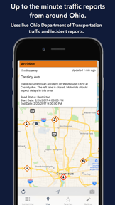

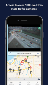


Ohio State Roads provides real-time traffic monitoring for Ohio commuters by integrating live data from the Ohio Department of Transportation. The app features a map-based interface for viewing 499 traffic cameras and incident reports, alongside a proximity-based list view for current road conditions.
Overview · Full Intel report in progress
The App DNA
What makes this app unique?
For Commuters and drivers in Ohio seeking real-time updates on traffic incidents, construction, and road conditions.
What does it look like?
Key features
Access to 499 traffic cameras across Ohio with the ability to save favorites for quick retrieval.
Visualizes current incidents and camera locations with color-coded icons indicating incident types and severity.
Displays current traffic incidents sorted by distance from the user's location, including road names and delay severity.
Provides at-a-glance information regarding the nearest current traffic incidents directly from the home screen.
How much does it cost?
Velocity
Intense developmentShow more...
3 versions in history. Development pace: intense.
Who built it?
Coderun Technologies
13+ apps tracked · Travel
 Illinois State Roads
 Florida Roads Traffic
 Wisconsin State Roads
 Tennessee State Roads
 Virginia State Roads
 North Carolina Roads Traffic
 Maryland Roads Traffic
 Alberta Roads
 UK Roads - Traffic & Cameras
 Queensland Roads
 Nevada State Roads
 California State Roads
User Sentiment
What do users think recently?
How are ratings & reviews evolving?
Not enough recent reviews to extract reliable themes yet.
Read the full review analysisCompetition
Competitive landscape for Ohio State Roads
How's the Travel market?
The rivals identified
The Analyst's Read
Key takeaways for Ohio State Roads
Where is it heading?
Bottom line
While the app offers comprehensive ODOT-sourced traffic data, user feedback highlights potential reliability issues with camera auto-refresh functionality.
Report last updated