


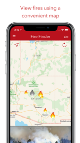

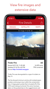

Fire Finder is a paid utility that aggregates wildfire data and satellite imagery from state and federal sources like inciweb.org and fire.ca.gov. It provides users with map-based visualizations of active fire perimeters and a photo gallery of wildfire events. The app is designed to help users track and share information regarding wildfire locations across the United States.
Overview · Full Intel report in progress
The App DNA
What makes this app unique?
For Individuals living in or traveling through regions prone to wildfire activity who require localized fire status updates.
What does it look like?
Key features
Displays wildfire locations and active fire perimeter data on a map interface.
Sources fire information from official state and federal agencies including the U.S. Forest Service and geomac.gov.
Provides access to images of wildfires where available.
Allows users to share fire images and specific incident information with others.
How much does it cost?
Velocity
Dormant developmentShow more...
5 versions in history. Development pace: zombie.
Who built it?
Scott Martin
3 apps tracked · News
 Villa Eats - Food Delivery
 News Maker - Create The News
User Sentiment
What do users think recently?
How are ratings & reviews evolving?
Not enough recent reviews to extract reliable themes yet.
Read the full review analysisCompetition
Competitive landscape for Fire Finder - Wildfire Info
How's the News market?
The rivals identified
The Analyst's Read
Key takeaways for Fire Finder - Wildfire Info
Where is it heading?
Bottom line
Recent user feedback indicates significant reliability issues regarding the timeliness and accuracy of wildfire data, which undermines the app's core utility.
Report last updated