


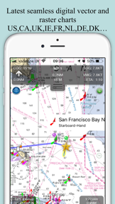

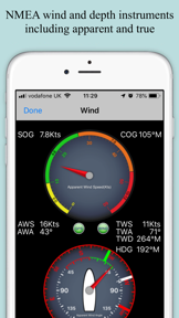
SeaNav US is a marine navigation tool for boaters that provides real-time access to NOAA digital vector charts for US coastal and inland waters. The app distinguishes itself with advanced features like live augmented reality camera views, NMEA over Wi-Fi integration, and collision alerts via Boat Beacon.
Overview · Full Intel report in progress
The App DNA
What makes this app unique?
For Recreational boaters and maritime professionals navigating US coastal, Great Lakes, and inland waterways.
What does it look like?
Key features
Provides comprehensive coverage of US coastal, ICW, and Great Lakes charts with tappable buoys and depth data.
Offers a unique live camera overlay to assist with real-time navigation and situational awareness.
Supports waypoint management, ETA calculations, and GPX file exchange for compatibility with MFDs.
Enables live ship tracking, collision alerts, and external data connectivity via Wi-Fi.
How much does it cost?
Velocity
Who built it?
Pocket Mariner
8 apps tracked · Navigation
 Boat Beacon
 SeaNav
 SeaNav UK & Ireland
 Boat Watch - Ship Tracking
 SeaNav NP
 Compass Eye Bearing Compass
 Boat Watch Pro
User Sentiment
What do users think recently?
How are ratings & reviews evolving?
Not enough recent reviews to extract reliable themes yet.
Read the full review analysisCompetition
Competitive landscape for SeaNav US
How's the Navigation market?
The rivals identified
The Analyst's Read
Key takeaways for SeaNav US
Where is it heading?
Bottom line
SeaNav US is a robust, one-time purchase navigation suite that leverages official NOAA data and AR technology to support complex route planning and real-time vessel monitoring.
Report last updated