


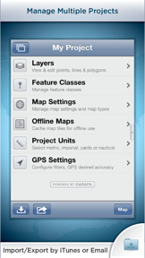

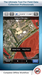

GIS Kit is a mobile field data collection and mapping tool for iOS that functions entirely offline without requiring desktop software or specialized GIS training. It enables users to import ESRI Shapefiles and KML/KMZ files, collect geographic features via GPS, and manage custom attribute data through pre-built templates.
Overview · Full Intel report in progress
The App DNA
What makes this app unique?
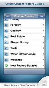
For Field professionals in sectors such as forestry, wetland delineation, stream surveying, and real estate.
What does it look like?
Key features
Allows users to cache topographic, street, and satellite imagery directly on the device for use without an internet connection.
Supports the import and export of ESRI Shapefiles and KML/KMZ files, including associated attribute data, via email.
Enables manual or GPS-based creation of point, line, and polygon features with customizable attribute fields like photos, dates, and numerical values.
Includes pre-configured templates for specific professional workflows, with the ability to create custom user-defined feature classes.
How much does it cost?
Velocity
Dormant developmentShow more...
5 versions in history. Development pace: zombie.
Who built it?
Garafa
3 apps tracked · Navigation
 GPS Kit - Offline GPS Tracker
 EclipseGo - 2026 Total Eclipse
User Sentiment
What do users think recently?
How are ratings & reviews evolving?
Not enough recent reviews to extract reliable themes yet.
Read the full review analysisCompetition
Competitive landscape for GIS Kit
How's the Navigation market?
The rivals identified
The Analyst's Read
Key takeaways for GIS Kit
Where is it heading?
Bottom line
While the app offers a robust, offline-capable feature set for field data collection, recent user feedback indicates significant concerns regarding app stability and developer support.
Report last updated