




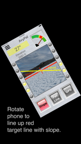

AvyPal is an iPhone application designed to assist backcountry travelers in identifying avalanche-prone terrain using camera-based visualization. The app utilizes color-coded indicators and GPS data to provide real-time slope angle analysis and risk alerts.
Overview · Full Intel report in progress
The App DNA
What makes this app unique?
For Backcountry travelers and outdoor enthusiasts navigating mountainous terrain.
What does it look like?
Key features
Displays the slope angle and associated avalanche risk for terrain intended for ascent or descent.
Provides angle and avalanche risk assessment for slopes that the user intends to cross.
Delivers audible alerts every five seconds when the user is in terrain identified as having avalanche risk.
Uses color-coded overlays, including red for high-probability avalanche slopes, to visualize terrain danger.
How much does it cost?
Velocity
Dormant developmentShow more...
5 versions in history. Development pace: zombie.
Who built it?
Timothy Kelley
13+ apps tracked · Sports
 ProMasterLevel
 RevelLevel
 SprinterLevel
 HeyBear!
 FlightSight
 SkateCoach
 gpsA2Bmap
 EZLapCounter
 LineEmUp
 PeakPal
 gpsTargetSetup
 EZElevation
User Sentiment
What do users think recently?
How are ratings & reviews evolving?
Not enough recent reviews to extract reliable themes yet.
Read the full review analysisCompetition
Competitive landscape for AvyPal
How's the Sports market?
The rivals identified
The Analyst's Read
Key takeaways for AvyPal
Where is it heading?
Bottom line
AvyPal provides real-time, camera-based slope angle analysis and audible GPS alerts to help users identify potential avalanche hazards in the backcountry.
Report last updated