


Avalanche Inclinometer
By Iterum

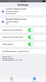
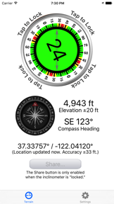

Avalanche Inclinometer is a specialized terrain-measurement tool for backcountry skiers and riders on iOS and Android.
The App DNA
What makes this app unique?
The app removes the cognitive friction of deciphering tiny carpenter-grade clinometer buttons in stormy weather by providing high-contrast, audio-enabled slope data.
For Backcountry skiers and riders who require precise terrain data to assess avalanche risk.
What does it look like?
Key features
Displays terrain data using large fonts for readability in high-glare or low-light conditions
Speaks the slope angle aloud so users can measure terrain without looking at the screen
Exports current location, slope, and elevation data via email as KML and GPX files
How much does it cost?
Paid model anchored at $3.99, positioned as a low-cost alternative to ski resort beverage pricing to lower the barrier to entry.
Velocity
Steady developmentShow more...
Who built it?


User Sentiment
What do users think recently?
Review voice lately leans excited. Users appreciate slope angle awareness provided by the inclinometer tool supports safer travel decisions in avalanche terrain and audio feedback and intuitive interface design make the tool easy to use during outdoor activities.
How are ratings & reviews evolving?
What users say, by theme
- Slope angle awareness provided by the inclinometer tool supports safer travel decisions in avalanche terrain
- Audio feedback and intuitive interface design make the tool easy to use during outdoor activities
- Mandatory location services for compass functionality frustrate users who prefer offline or airplane mode operation
4 of 4 recent reviews analyzed · limited sample
Read the full review analysisCompetition
Competitive landscape for Avalanche Inclinometer
How's the Sports market?
Avalanche Inclinometer occupies a niche utility segment within the Sports category, with a 4.5-star rating across 36 total reviews. Its $3.99 price point targets the specialized backcountry segment, positioning it as a low-cost safety tool compared to broader, subscription-based navigation rivals.
Read the market outlookThe rivals identified
Unlock the deeper market read.
Access the full report for freeThe Analyst's Read
Key takeaways for Avalanche Inclinometer
Where is it heading?
The backcountry safety tool market is consolidating around apps that provide both navigation and specific terrain data, putting pressure on single-purpose tools. Avalanche Inclinometer remains advantaged by its specialized focus, but the lack of offline-capable orientation leaves it exposed to rivals that offer more robust remote-area functionality.
- Mandatory GPS dependency for compass functionality frustrates users in remote areas, which limits the app's utility during critical backcountry safety checks.
- Audio feedback and high-contrast design remain core differentiators, sustaining positive sentiment among this app backcountry audience despite the offline-mode friction.
The SWOT
- Audio feedback enables terrain assessment without screen interaction
- High-contrast interface ensures readability in extreme weather
- Implement offline-capable compass sensors to remove primary friction
Next best moves
Ship offline-capable compass mode because reviews flag GPS dependency as the top frustration theme → reduce churn in the core backcountry segment
+ 1 more prioritized moveThe counter-intuitive read
The app's reliance on specialized, high-contrast hardware-like utility is a strength…
Read the full takeFeature gaps
Offline-first compass orientation (available in broader navigation rivals but missing here)
Since the last report: The app has transitioned from a generic utility to a specialized backcountry tool, marked by the introduction of data export features and the surfacing of critical user friction regarding mandatory GPS connectivity.
Bottom line
Implementing offline-capable compass sensors would address the primary friction point driving user frustration, securing the app's position against broad navigation rivals. This move would unlock higher retention among the core backcountry segment that frequently operates in low-connectivity environments.
Unlock 2 critical frictions, 1 market threat, 1 more prioritized move and the analyst’s take.
Access the full report for freeFAQ
Is Avalanche Inclinometer safe to use in remote backcountry areas?
How does Avalanche Inclinometer compare to onX Backcountry?
Does Avalanche Inclinometer work in airplane mode?
Is there a free version of Avalanche Inclinometer?
Sources
- [1] Play Store listing
- [2] Developer website, source
Report last updated