


Marine Navigation-USA Lake Map
By Bist


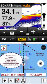

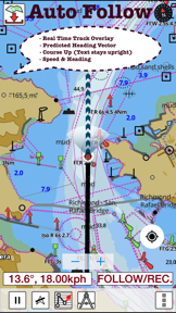
Marine Navigation-USA Lake Map provides comprehensive nautical charting, including NOAA vector charts, USACE inland river maps, and freshwater lake maps. It distinguishes itself as a marine GPS tool featuring voice-prompted route assistance and real-time track overlays. The app is designed for boaters and anglers requiring precise navigation, route management, and environmental data like tides and currents.
Overview · Full Intel report in progress
The App DNA
What makes this app unique?
For Recreational boaters, offshore anglers, and mariners requiring reliable GPS navigation and route planning tools.
What does it look like?
Key features
Provides audible alerts for route markers, off-route warnings, and continuous ETA updates.
Offers hardware-accelerated vector charts, seamless chart quilting, and 1ft/3ft depth contour maps for anglers.
Supports the creation of custom boating routes and the import of existing GPX/KML files.
Includes integrated tide and current prediction tools for improved situational awareness.
How much does it cost?
Velocity
Dormant developmentShow more...
5 versions in history. Development pace: zombie.
Who built it?
Bist
12 apps tracked · Navigation
 i-Boating: USA Marine Charts
 Fishing Points - Lake Maps
 i-Hunting : GPS Maps App
 i-Boating : Marine Navigation
 i-Boating:HD Gps Marine Charts
 Marine Weather-Wind Tide Wave
 Marine Navigation - Canada
 i-Boating: WMTS-Marine & Lakes
 i-Boating Spain: Marine Charts
 i-Boating: Canada & USA - Marine / Nautical Navigation Charts for fishing & sailing
 i-Boating: Marine Charts & Gps
User Sentiment
What do users think recently?
How are ratings & reviews evolving?
Not enough recent reviews to extract reliable themes yet.
Read the full review analysisCompetition
Competitive landscape for Marine Navigation-USA Lake Map
How's the Navigation market?
The rivals identified
The Analyst's Read
Key takeaways for Marine Navigation-USA Lake Map
Where is it heading?
Bottom line
While the app offers robust navigation features and specialized charting, recent user feedback indicates potential stability issues that may impact reliability.
Report last updated