


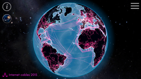
Connected Earth is an educational visualization tool that maps global transport and communication infrastructure. It allows users to overlay data layers including roads, railways, shipping lanes, and submarine cables to analyze planetary connectivity. The app aims to provide a unified perspective on how human systems link populated areas across the globe.
Overview · Full Intel report in progress
The App DNA
What makes this app unique?
For Students, educators, and geography enthusiasts interested in global infrastructure and logistics.
What does it look like?
Key features
Overlays roads, railways, navigable rivers, shipping lanes, and flight routes to illustrate global movement.
Displays submarine cables to reveal how the world's populated areas interact digitally.
Provides a unified view of the planet to demonstrate the intricate relationships between various transport and communication systems.
How much does it cost?
Velocity
Maintenance developmentShow more...
3 versions in history. Development pace: maintenance.
Who built it?
Celestial Dynamics AG
4 apps tracked · Education
 Cosmic-Watch
 Earth's Core
 Cosmic Deepsky
User Sentiment
What do users think recently?
How are ratings & reviews evolving?
Not enough recent reviews to extract reliable themes yet.
Read the full review analysisCompetition
Competitive landscape for Connected Earth
How's the Education market?
The rivals identified
The Analyst's Read
Key takeaways for Connected Earth
Where is it heading?
Bottom line
While the app offers a unique educational visualization of global infrastructure, user feedback highlights significant performance issues regarding data density and image clarity at high zoom levels.
Report last updated