



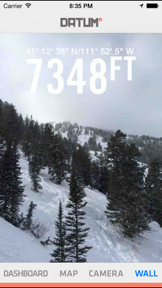


Datum GPS Photography is a navigation-focused camera app for iOS that overlays real-time GPS coordinates, altitude, and heading onto photos.
The App DNA
What makes this app unique?
The app removes the friction of manual metadata logging for outdoor field documentation by embedding sensor data directly into the camera roll.
For Outdoor enthusiasts and travelers requiring precise location tracking and geo-stamped photography.
What does it look like?
Key features
Displays real-time heading, altitude, and coordinate data alongside a live map view.
Captures images with Latitude, Longitude, and Elevation overlays directly within the app.
Allows users to save images to the camera roll or share #datumshot content via social media.
How much does it cost?
The app operates on a free model without disclosed in-app purchases, positioning it as a basic utility tool.
Velocity
Steady developmentShow more...
Who built it?
AppJester
5 apps tracked · Navigation
 Purrge
 Craters of the Moon - Flowers
 Craters Rocks! Geology of Craters of the Moon
 Famous Movie Props
User Sentiment
What do users think recently?
How are ratings & reviews evolving?
Not enough recent reviews to extract reliable themes yet.
Read the full review analysisCompetition
Competitive landscape for Datum GPS Photography - GPS dashboard with location stamped photography
How's the Navigation market?
Datum maintains a niche position in the navigation category with a 3.0 rating based on 2 total reviews. The lack of updates since 2016 creates a significant competitive disadvantage against rivals with active update cadences.
The rivals identified

By AppziBrain Infotech LLP
MapStamp directly competes by offering a high-volume, feature-rich alternative for GPS-stamped photography that dominates the category through massive user scale and frequent updates.
- Offers extensive brand logo overlay options that provide professional utility for business and field documentation users.
- Maintains a massive user base with hundreds of thousands of reviews, creating a significant social proof barrier.
- Provides advanced template customization that allows users to tailor metadata layouts far beyond basic coordinate stamping.


Unlock the head-to-head verdict: where this rival wins, and where it loses.
Access the full report for freeThe Analyst's Read
Key takeaways for Datum GPS Photography - GPS dashboard with location stamped photography
Where is it heading?
The navigation photography market is consolidating around apps with high-frequency update cadences and professional template tools. Datum's current trajectory is declining due to the absence of development, which will likely lead to further user churn as OS-level incompatibilities accumulate.
- The lack of updates since 2016 indicates a maintenance-only posture, which erodes user trust and prevents compatibility with modern hardware features.
The SWOT
- Integrated dashboard-camera workflow provides a single-screen utility for field data capture
- Pivot toward a specialized dashboard-first utility focus to avoid direct feature wars
Next best moves
Audit OS compatibility because the app has not updated since 2016 → prevent total failure on modern iOS versions
The counter-intuitive read
The lack of updates is not just a failure but a strategic constraint…
Read the full takeFeature gaps
Professional branding/logo overlays (available in MapStamp but missing here) +1
Since the last report: Datum GPS Photography has transitioned from a standard utility to a maintenance-mode product, with the analysis now formally documenting its lack of updates since 2016 and the resulting competitive pressure from active rivals.
Bottom line
Datum's integrated dashboard-camera utility retains a niche appeal, but the lack of updates since 2016 necessitates a pivot toward a specialized, maintenance-light focus to remain viable against active competitors.
Unlock 1 critical friction, 1 market threat and the analyst’s take.
Access the full report for freeFAQ
Is Datum GPS Photography still receiving updates?
How does Datum compare to MapStamp?
What is a good alternative to Datum for geo-stamped photos?
Sources
- [1] App Store, source
Report last updated