


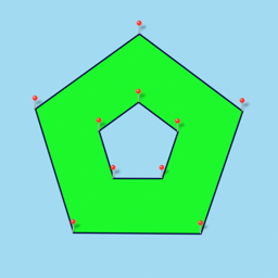


Distance and Area Measure is a satellite-based mapping tool designed for calculating distances, perimeters, and land areas. It distinguishes itself from competitors through advanced geometry editing capabilities, such as support for self-intersecting polygons, nested inner polygons, and granular path manipulation.
Overview · Full Intel report in progress
The App DNA
What makes this app unique?
For Professionals and hobbyists requiring precise geospatial measurements for land, infrastructure, or environmental planning.
What does it look like?
Key features
Allows users to draw interior polygons, swap path points, and add nodes to the middle of existing paths.
Includes support for UTM and MGRS grids alongside KML file import and export functionality.
Provides both forward geocoding for address searches and reverse geocoding to identify locations from coordinates.
Offers configurable distance and area units with specific fields for naming, noting, and color-coding individual map elements.
How much does it cost?
Velocity
Maintenance developmentShow more...
5 versions in history. Development pace: maintenance.
Who built it?
TappiApps
9 apps tracked · Productivity
 GPS Odometer Pro
 Distance and Area Measure
 My GPS Coordinates
 GPS Odometer
 Radius on Map : draw circle
 My GPS Coordinates Pro
 Radius on Map + : draw circle
 Radius on Map
User Sentiment
What do users think recently?
How are ratings & reviews evolving?
Not enough recent reviews to extract reliable themes yet.
Read the full review analysisCompetition
Competitive landscape for Distance and Area Measure
How's the Productivity market?
The rivals identified
The Analyst's Read
Key takeaways for Distance and Area Measure
Where is it heading?
Bottom line
While the app offers high-utility technical features for complex mapping, user feedback indicates significant dissatisfaction with the interface usability and overall performance.
Report last updated