


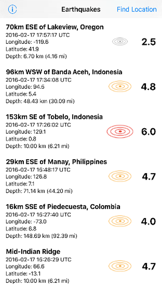
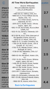
Earthquake News is a utility app that aggregates real-time seismic data from the USGS for events with a magnitude of 2.5 or higher. It provides users with detailed event metrics, map-based visualization, and direct links to official USGS reports. The app is notable for its integration with native mapping services to display both earthquake locations and the user's current position.
Overview · Full Intel report in progress
The App DNA
What makes this app unique?
For Individuals interested in monitoring global seismic activity and earthquake data in near real-time.
What does it look like?
Key features
Displays a list of earthquakes magnitude 2.5 and above from the past 7 days, refreshable via a pull-to-refresh gesture.
Provides specific metrics for each event, including location, magnitude, UTC time, coordinates, and depth.
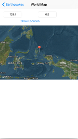
Links to the native Map app to plot earthquake locations alongside the user's current position.
Includes a secondary view that allows users to input specific latitude and longitude coordinates to visualize associated locations.
How much does it cost?
Velocity
Who built it?
Manfred Breede
13+ apps tracked · Utilities
 Decimal To Fraction Converter
 Pre-Press File Size
 Duffer's Golf Score Card
 Earthquake Report
 Font Sizes
 Kelly Paper M to Basis Weight
 Kelly Paper Basis to M-Weight
 Decimal To Fraction Plus
 Scale Factor
 Flexo Plate Distortion
 Scaling for a New Size
 Any Roll Length
User Sentiment
What do users think recently?
How are ratings & reviews evolving?
Not enough recent reviews to extract reliable themes yet.
Read the full review analysisCompetition
Competitive landscape for Earthquake News
How's the Utilities market?
The rivals identified
The Analyst's Read
Key takeaways for Earthquake News
Where is it heading?
Bottom line
This is a straightforward, paid utility for tracking recent global seismic activity using official USGS data.
Report last updated