



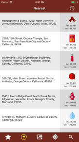
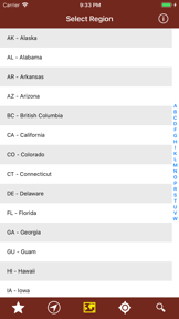

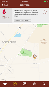


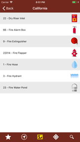
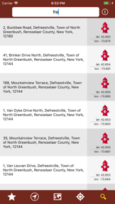
Firefighters Emergency is a location-based utility for finding fire safety infrastructure across the United States on iOS and Android.
The App DNA
What makes this app unique?
The app removes the friction of searching for localized emergency equipment by aggregating open-source data into a single map interface.
For Users in the United States requiring location data for fire emergency facilities and equipment.
What does it look like?
Key features
Displays fire emergency facilities and equipment locations using OpenStreetMap and OverpassTurbo data.
Locates facilities by region, US state, address, street name, or GPS coordinates.
Allows users to save specific fire emergency facilities and equipment for quick access.
How much does it cost?
Ad-supported model relies on third-party map data to provide utility without subscription fees.
Velocity
Maintenance developmentShow more...
5 versions in history. Development pace: maintenance.
Who built it?
Andrea Bisegna
13+ apps tracked · Productivity
 NOAA Alerts Weather PRO
 NOAA Aviation Live Sky Weather
 NOAA Buoys Live Marine Weather
 NOAA Alerts Weather
 NOAA Center Hurricane
 NOAA National Data Buoy Marine
 NOAA AWC Aviation Weather
 NOAA Snow Live Weather
 记忆游戏 - 发现卡背后的动物
 NOAA Aviation PRO Live Weather
 Multi Weather Forecast
 NOAA Buoys Marine Weather PRO
User Sentiment
What do users think recently?
How are ratings & reviews evolving?
Not enough recent reviews to extract reliable themes yet.
Read the full review analysisCompetition
Competitive landscape for Firefighters Emergency
How's the Productivity market?
Firefighters Emergency serves a niche utility segment, relying on open-source data to maintain a free-to-use model.
Read the market outlookThe rivals identified
Unlock the deeper market read.
Access the full report for freeThe Analyst's Read
Key takeaways for Firefighters Emergency
Where is it heading?
The utility market for specialized infrastructure mapping is consolidating around tools with robust offline support, leaving Firefighters Emergency exposed to churn during network outages. The lack of recent feature updates signals a maintenance-only posture, which will likely result in a slow decline in user engagement as competitors improve their offline capabilities.
- The app remains in maintenance mode with no significant feature expansion, limiting its ability to compete with modern mapping tools.
The SWOT
- Open-source data integration removes licensing costs
- Implementing local caching for saved favorites
Next best moves
Ship local caching for favorites because the app requires connectivity for all data access → increase utility during outages
The counter-intuitive read
The app's reliance on open-source data is a strength, not a weakness…
Read the full takeSince the last report: The report has shifted from a general assessment of mapping utility to a targeted critique of the app's connectivity dependency. The primary change is the formalization of offline data access as the critical bottleneck for the product's professional viability.
Bottom line
Firefighters Emergency provides a functional directory for fire safety infrastructure, but the lack of offline capability limits its utility during actual emergencies. Prioritizing local data caching would address the primary frustration regarding connectivity, which currently prevents the app from becoming a reliable field tool.
Unlock 1 critical friction, 1 market threat and the analyst’s take.
Access the full report for freeFAQ
Is Firefighters Emergency free to use?
Does Firefighters Emergency work without an internet connection?
Where does the app get its fire emergency data?
Sources
- [1] Play Store listing, source
Report last updated