


GNSS View
By NEC
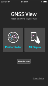


GNSS View is a navigation utility developed by NEC Corporation that visualizes the positioning of QZSS and GPS satellites in the sky. It allows users to simulate satellite arrangements for specific times and locations to assess potential signal obstructions caused by environmental factors like buildings or trees.
Overview · Full Intel report in progress
The App DNA
What makes this app unique?
For Professionals and enthusiasts requiring precise satellite visibility data for GNSS positioning and signal analysis.
What does it look like?
Key features
Displays the real-time or scheduled position of QZSS and GPS satellites in the sky.
Allows users to specify custom coordinates and timeframes to view satellite arrangements.
Helps users identify if satellite signals are likely to be blocked by physical obstacles such as trees or buildings.
How much does it cost?
Velocity
Active developmentShow more...
5 versions in history. Development pace: active.
Who built it?
NEC
13+ apps tracked · Navigation
 入退記録(GPS連携サービス)
 WoLN 健康を楽しく習慣に/健康活動でポイントが貯まる
 UNIVERGE 3C Mobile Client
 UNIVERGE ST500
 GNSS Analyzer
 UNIVERGE 3C Mobile Client Plus
 NEHOPS Smart
 みちびき避難所
 GPS勤怠管理 for 勤革時 【従業員用】
 Admin GPS勤怠管理 for 勤革時 【管理者用】
 OneNEC BC Support App
 顔決済サービスApp
User Sentiment
What do users think recently?
How are ratings & reviews evolving?
Not enough recent reviews to extract reliable themes yet.
Read the full review analysisCompetition
Competitive landscape for GNSS View
How's the Navigation market?
The rivals identified
The Analyst's Read
Key takeaways for GNSS View
Where is it heading?
Bottom line
This tool provides predictive satellite positioning data to help users verify signal availability and identify potential environmental interference.
Report last updated