


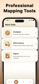
GPS Field Area Calculator: GPQ is a land and terrain measurement utility for iOS that uses GPS coordinates and interactive maps to calculate area and distance.
The App DNA
What makes this app unique?
The app removes the need for manual measurement tools by providing a digital, organized repository for property and project-based spatial data.
For Professionals and individuals requiring land, plot, and outdoor space measurements for planning or property projects.
What does it look like?
Key features
Calculates land, plot, and terrain area using GPS coordinates and interactive maps.
Saves and categorizes measurement projects for future retrieval, encouraging repeat usage.
Unlocks advanced features via auto-renewable subscription or one-time purchase.
How much does it cost?
The freemium model gates advanced mapping and measurement features behind a subscription or one-time payment, targeting users who require full access to mapping tools.
Velocity
Maintenance developmentopaqueShow more...
The app shows a maintenance-level cadence with only one release recorded in the current window. Development activity is currently limited to the initial launch, and there is no evidence of ongoing feature iteration or live operations. Future momentum remains to be established as the app has not yet moved beyond its first version.
Who built it?
Hardik Gojariya
8 apps tracked · Utilities
 Sound & Decibel Meter - dBScan
 Voice Changer & Modulator: EQO
 Cell Tower Locator - CellScope
 Menstrual Cycle Tracker: Ovina
 ID Scanner - Card Q
 AI Interior Design - SpaceQ
 ZIP & RAR Extractor - ZipZ
User Sentiment
What do users think recently?
How are ratings & reviews evolving?
Not enough recent reviews to extract reliable themes yet.
Read the full review analysisCompetition
Competitive landscape for GPS Field Area Calculator: GPQ
How's the Utilities market?
GPS Field Area Calculator: GPQ occupies the utilities category with a specialized focus on land measurement. The current maintenance-only release cadence suggests a low-touch strategy that relies on organic discovery rather than active chart competition.
The rivals identified
The Analyst's Read
Key takeaways for GPS Field Area Calculator: GPQ
Where is it heading?
The land measurement utility market is consolidating around tools that offer frequent API updates and offline capabilities. GPS Field Area Calculator: GPQ remains exposed to technical drift due to its current maintenance-only cadence, which risks user churn if mapping dependencies break.
- The app remains in a maintenance phase with no updates since the initial release 26 days ago, signaling a low-investment posture.
The SWOT
- Project organization library enables repeat usage by building a repository of user-specific measurement data.
- GPS-based coordinate mapping provides a standardized, accessible interface for land management tasks.
- Integration of offline map packs could address the connectivity dependency inherent in GPS-based field tools.
- Expansion into specialized industry templates could differentiate the tool from generic area calculators.
Next best moves
Audit mapping API compatibility because the app has not updated since launch → maintain baseline functionality
The counter-intuitive read
The app's lack of updates is a strategic…
Read the full takeSince the last report: The app's positioning shifted from a general-purpose land measurement utility to an estimation-only tool, accompanied by a more granular assessment of technical risks related to mapping API stability.
Bottom line
GPS Field Area Calculator: GPQ relies on a standard feature set that requires consistent maintenance to remain viable against platform-level mapping updates. Prioritizing a stable release cadence would defend the tool's utility against technical drift.
Unlock 2 critical frictions, 1 market threat and the analyst’s take.
Access the full report for freeFAQ
Is GPS Field Area Calculator: GPQ suitable for professional land surveying?
Does GPS Field Area Calculator: GPQ offer a free version?
What should I use if I need highly accurate property boundary measurements?
Sources
- [1] App Store, source
Report last updated