




GPS Field Area Measure is a land and distance calculation tool for farmers and surveyors, structured around GPS-based interactive map drawing on iOS.
The App DNA
What makes this app unique?
The app removes the need for expensive, dedicated surveying hardware for basic area estimation, allowing users to perform site planning directly on their mobile devices.
For Farmers, land surveyors, real estate professionals, and construction contractors requiring mobile-based land measurement tools.
What does it look like?
Key features
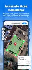
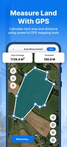
Calculates land and field surface area using device location services and interactive map drawing. Core utility function that drives initial install and retention for professional users.
Supports area and distance calculations across nine units including acres, hectares, and square meters. Retention lever for professional workflows requiring specific regional or industry-standard units.
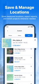
Saves and organizes past measurement records for future access. Premium-tier gate, serving as a direct paid-conversion lever for users needing to manage multiple project sites.
Allows manual boundary plotting on map interface for area estimation. Engagement loop that increases time-in-app during site planning sessions.
How much does it cost?
Subscription model uses auto-renewing billing via iTunes, with premium features gated behind active membership.
Velocity
Maintenance developmentperformanceopaqueShow more...
GPS Field Area Measure maintains a maintenance-level cadence, with two releases occurring over the last 30 days. The developer is currently focused exclusively on performance and stability, as evidenced by the lack of new features in the latest release. Development activity remains stable but limited, with no indication of a shift toward live operations or major feature expansion. The publisher provides opaque release notes, offering no insight into specific technical improvements or bug resolutions.
Who built it?
Nikung Goyani
4 apps tracked · Utilities
 Two Factor Authenticator 2FA
 AwaazEye: Real-Time City Alert
 Finance-Calculator
User Sentiment
What do users think recently?
How are ratings & reviews evolving?
Not enough recent reviews to extract reliable themes yet.
Read the full review analysisCompetition
Competitive landscape for GPS Field Area Measure
How's the Utilities market?
Users report: GPS Field Area Measure occupies a niche utility space for land measurement, relying on a subscription model to monetize data persistence. The lack of recent feature updates, with only maintenance-level fixes in the last three months, limits its ability to compete against more actively developed surveying tools.
Read the market outlookThe rivals identified
Unlock the deeper market read.
Access the full report for freeThe Analyst's Read
Key takeaways for GPS Field Area Measure
Where is it heading?
The land measurement utility market is consolidating around tools that offer higher reliability and offline capability. GPS Field Area Measure remains stable but exposed: without active feature investment, it will struggle to retain professional users who require more than basic map-drawing functionality.
- Maintenance-only release cadence (bug fixes only) suggests the product is in a defensive lifecycle phase rather than an active growth stage.
- Reliance on subscription-gated history management creates a high churn risk if the app does not deliver new utility to justify recurring costs.
The SWOT
- Interactive map-based boundary plotting enables precise area estimation for non-surveyors
- Localized unit support for niche regional agricultural standards could capture underserved users
Next best moves
Audit the premium-tier conversion funnel because the current history-management gate is the only clear value-add for paid users → increase conversion rate.
+ 1 more prioritized moveThe counter-intuitive read
The app's disclaimer regarding GPS accuracy is not…
Read the full takeBottom line
The current maintenance-only posture leaves GPS Field Area Measure vulnerable to more agile competitors, so pivoting the roadmap toward offline-first reliability would unlock higher retention among the core professional user base.
Unlock 1 critical friction, 1 market threat, 1 more prioritized move and the analyst’s take.
Access the full report for freeFAQ
Is GPS Field Area Measure accurate enough for legal property boundaries?
Does GPS Field Area Measure require a subscription?
What are the alternatives to GPS Field Area Measure for land surveying?
Sources
- [1] App Store, source
Report last updated