


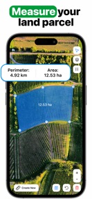
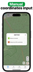


GPS Field Area Measure on Map is a utility for land surveyors and farmers to calculate plot areas and generate geo-tagged photo documentation on iOS.
The App DNA
What makes this app unique?
The app removes the need for separate surveying tools by combining map-based area measurement with environmental data stamping in a single workflow.
For Land surveyors, farmers, and real estate professionals requiring precise field measurements and geo-tagged documentation.
What does it look like?
Key features
Calculates land plot area by defining enclosed paths with map points.
Overlays location, weather, magnetic field, compass, and altitude data onto photos.
Exports measurement results into KML, KMZ, or PDF formats.
How much does it cost?
The subscription model uses high-frequency renewal options to capture revenue from both short-term project users and long-term professionals.
Velocity
Maintenance developmentperformanceShow more...
GPS Field Area Measure on Map currently operates on a maintenance cadence, with only one release identified in the recent window. The latest version provides only generic bug fixes, indicating a lack of new feature development or content updates. With 47 days since the last update, the development momentum is minimal and focused strictly on stability.
Who built it?
Anastasiia Kulias
4 apps tracked · Utilities
 Speedometer GPS, Speed Tracker
 Voice Recorder: Speech-to-Text
 Cell Tower Map: Signal Finder
User Sentiment
What do users think recently?
How are ratings & reviews evolving?
Not enough recent reviews to extract reliable themes yet.
Read the full review analysisCompetition
Competitive landscape for GPS Field Area Measure on Map
How's the Utilities market?
GPS Field Area Measure on Map maintains a 4.78 rating across 19 total reviews, reflecting a stable but niche user base. The absence of major updates in the last 47 days indicates a maintenance-focused market posture.
Read the market outlookThe rivals identified
Unlock the deeper market read.
Access the full report for freeThe Analyst's Read
Key takeaways for GPS Field Area Measure on Map
Where is it heading?
The utility market for land measurement is consolidating around tools that offer automated reporting and seamless data integration. GPS Field Area Measure on Map remains in a maintenance posture, which will likely erode its competitive standing as rivals introduce more frequent feature updates.
- The latest release contains only general bug fixes, confirming a maintenance-only cadence that avoids active feature expansion.
- The lack of major updates over 47 days limits the ability to capture new market segments, leaving the app exposed to more active competitors.
The SWOT
- GPS camera stamp provides geo-tagged documentation with weather and altitude data
- Expansion into automated KML/KMZ reporting workflows to capture professional segments
Next best moves
Ship automated KML/KMZ reporting workflows because the current manual export is a standard feature → increase professional retention
The counter-intuitive read
The maintenance-only phase is a strategic risk: in a utility category…
Read the full takeSince the last report: The app remains in a maintenance-only state, with no material changes to features or pricing. The primary shift is a minor 0.01 point decrease in the average rating and a more granular definition of competitive threats and opportunities.
Bottom line
GPS Field Area Measure on Map provides a functional tool for field documentation, but the maintenance-only cadence limits its growth. Prioritizing professional-grade export features would unlock higher value for the target audience and differentiate the app from standard calculators.
Unlock 1 critical friction, 1 market threat and the analyst’s take.
Access the full report for freeFAQ
Is GPS Field Area Measure on Map suitable for professional surveying?
Does GPS Field Area Measure on Map offer a free version?
What file formats can I export from GPS Field Area Measure on Map?
Sources
- [1] App Store, source
Report last updated