







Landscape Photography Helper is a celestial and terrain planning tool for landscape and drone photographers on iOS.
The App DNA
What makes this app unique?
Users hire the app to eliminate guesswork in light and celestial alignment, ensuring precise composition before arriving on location.
For Landscape and drone photographers who require precise planning for light, celestial alignment, and terrain composition.
What does it look like?
Key features
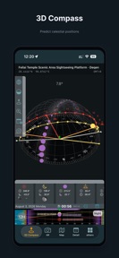
Simulates terrain occlusion and celestial paths using elevation data, serving as a primary conversion driver for the Pro subscription.
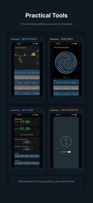
Visualizes flight altitude and lens perspective, targeting specialized drone photography workflows to justify premium pricing.
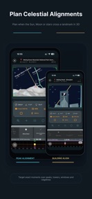
Enables precise celestial-to-structure alignment planning, increasing the utility of the Pro tier for urban photographers.
How much does it cost?
Freemium model gates high-precision simulation and map-based planning tools behind a Pro subscription.
Velocity
Maintenance developmentnew contentUX improvementsplatform expansionShow more...
The app maintains a steady release cadence of approximately one update per month, classifying it as maintenance-tier velocity. The latest release is a major update, focusing on expanding AR capabilities, sky search functionality, and regional map support. Development appears stable, with a clear focus on feature-rich updates rather than frequent iterative patches. There is no evidence of a live-ops strategy, as the update cycle is driven by feature expansion rather than recurring events.
Who built it?
永晓 邵
4 apps tracked · Photo & Video
 DoF Calculator
 LandscapePhotographyHelper Pro
 Heliora: Sun Path Tracker
User Sentiment
What do users think recently?
How are ratings & reviews evolving?
Not enough recent reviews to extract reliable themes yet.
Read the full review analysisCompetition
Competitive landscape for Landscape photography Helper
How's the Photo & Video market?
Landscape Photography Helper occupies a specialized utility niche in the Photo & Video category, maintaining a 4.7-star rating across 39 reviews. The focus on high-precision 3D planning distinguishes it from general-purpose photography apps.
Read the market outlookThe rivals identified
Unlock the deeper market read.
Access the full report for freeThe Analyst's Read
Key takeaways for Landscape photography Helper
Where is it heading?
The market for photography planning tools is shifting toward automated, AI-assisted composition. Landscape Photography Helper remains advantaged in high-precision technical planning, but the lack of social discovery features leaves it exposed to platforms that combine planning with community sharing.
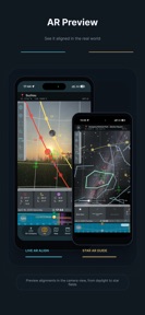
- The latest release added immersive AR modes and planet prediction, signaling active feature investment rather than maintenance mode.
The SWOT
- 3D VR terrain prediction system functions as a defensible barrier for high-precision landscape planning.
- Integrated drone database reflects real-world equipment performance for composition planning.
- Integration of user-generated location sharing could build a community-driven discovery layer.
- Expansion of architectural model library for urban photography planning.
Next best moves
Ship automated AR-to-map transition because manual planning is the top friction point for casual users → increase conversion to Pro
The counter-intuitive read
The app's manual planning complexity is a feature, not a bug…
Read the full takeSince the last report: The report identifies a shift in competitive risk, moving from concerns about release cadence to concerns about manual workflow friction and AI-driven automation.
Bottom line
Landscape Photography Helper retains power users through high-precision 3D terrain and drone simulation, but the manual planning requirement limits its appeal to casual photographers, so the PM should prioritize simplifying the AR-to-map transition to reduce user churn.
Unlock 2 critical frictions, 2 market threats and the analyst’s take.
Access the full report for freeSources
Report last updated