


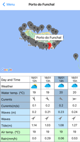
MadeiraOcean is an experimental weather and oceanographic forecasting tool that visualizes COAWST model data for the Madeira Archipelago. It provides localized environmental insights, including atmospheric and marine conditions, for over 30 specific points around the island.
Overview · Full Intel report in progress
The App DNA
What makes this app unique?
For Researchers, maritime professionals, and individuals interested in localized oceanographic and atmospheric conditions around Madeira.
What does it look like?
Key features
Displays graphical forecasts for air and water temperature, currents, waves, tides, precipitation, wind, and atmospheric pressure.
Provides three-hour interval forecasts for more than 30 distinct geographic points around the Madeira Archipelago.
Incorporates real-time satellite data for sea surface temperature and Chlorophyll-a concentrations via the Copernicus Marine Service.
How much does it cost?
Velocity
Active developmentShow more...
3 versions in history. Development pace: active.
Who built it?
AGENCIA REGIONAL PARA O DESENVOLVIMENTO DA INVESTIGACAO, TECNOLOGIA E INOVACAO - ASSOCIACAO
7 apps tracked · Weather
 Dive Reporter
 Marine Bioinvasions Conference
 MadeiraFish
 The Future Is
 AQUAFISH Chef
 Madeira Weather
User Sentiment
What do users think recently?
How are ratings & reviews evolving?
Not enough recent reviews to extract reliable themes yet.
Read the full review analysisCompetition
Competitive landscape for MadeiraOcean
How's the Weather market?
The rivals identified
The Analyst's Read
Key takeaways for MadeiraOcean
Where is it heading?
Bottom line
This is an experimental data visualization tool for environmental monitoring that explicitly notes its forecasts are predictive and subject to validation limitations.
Report last updated