


New York City Subway 3D Map
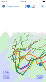


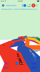
New York City Subway 3D Map is a 3D transit visualization tool for iOS that allows users to explore the New York City subway layout and simulate rides.
The App DNA
What makes this app unique?
The app removes the cognitive friction of visualizing complex underground transit depths, serving transit enthusiasts who prefer spatial exploration over standard 2D navigation.
For Transit enthusiasts and New York City subway riders interested in the physical layout and depth of the transit system.
What does it look like?
Key features
Visualizes the New York City subway system using actual ground elevations, track depths, and station locations.
Provides a virtual ride experience between user-selected start and end stations on the subway network.
Allows users to zoom, pan, rotate, and tilt the 3D map using standard iOS touch gestures.
How much does it cost?
The app is distributed as a free utility with no visible in-app purchases or subscription tiers.
Velocity
Dormant developmentopaqueShow more...
The app has reached a zombie state, with no updates or feature releases in 1,645 days. Development activity has been non-existent for several years, indicating the project is no longer supported. There is no evidence of ongoing maintenance or operational activity.
Who built it?
Geoffrey Domm
6 apps tracked · Education
 London Tube 3D Map
 NOAA Forecast
 CelestialGuide
 CurlingSimulator
 Moscow Metro 3D Map
User Sentiment
What do users think recently?
The recent review mood reads mixed. Users appreciate the core subway simulation experience provides an engaging loop for transit enthusiasts who enjoy virtual rail management.
How are ratings & reviews evolving?
What users say, by theme
- The core subway simulation experience provides an engaging loop for transit enthusiasts who enjoy virtual rail management
- Geographic inaccuracies in the map design frustrate users who expect a higher level of spatial realism
2 of 2 recent reviews analyzed · limited sample
Read the full review analysisUnlock 1 user request, each backed by review evidence.
Access the full report for freeCompetition
Competitive landscape for New York City Subway 3D Map
How's the Education market?
New York City Subway 3D Map holds a 3.5-star rating from 4 total ratings. The lack of updates for over 4 years positions the app as a legacy utility rather than a competitive navigation tool.
Read the market outlookThe rivals identified
Unlock the deeper market read.
Access the full report for freeThe Analyst's Read
Key takeaways for New York City Subway 3D Map
Where is it heading?
The transit-utility market is consolidating around apps that provide live data, leaving static visualization tools like New York City Subway 3D Map increasingly isolated. Without a pivot to real-time data or a major accuracy overhaul, the app will continue to lose relevance to modern navigation rivals.
- The lack of updates for over 4 years suggests the developer has abandoned the project, leading to inevitable obsolescence.
- User complaints regarding geographic inaccuracies remain unaddressed, which will continue to erode the app's reputation among transit enthusiasts.
The SWOT
- 3D visualization of track depths provides a unique spatial perspective
- Integrating real-time transit data could increase utility for daily commuters
Next best moves
Audit map data for geographic accuracy because users report spatial inaccuracies → increase user trust
+ 1 more prioritized moveThe counter-intuitive read
The app's lack of real-time data is not a failure…
Read the full takeBottom line
New York City Subway 3D Map serves a niche interest in transit visualization, but the lack of updates since 2022 renders it a legacy project. Addressing geographic inaccuracies is the only path to regaining user trust.
Unlock 2 critical frictions, 1 market threat, 1 more prioritized move and the analyst’s take.
Access the full report for freeFAQ
Is New York City Subway 3D Map accurate for navigation?
Does New York City Subway 3D Map provide real-time train times?
Are there better alternatives for NYC subway navigation?
Sources
- [1] App Store
Report last updated