


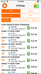


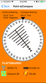

OTAMap is a utility tool designed to help users locate and orient antennas for Over The Air (OTA) television and FM radio reception. The app maps transmission tower locations within a 150-mile radius of the user's current position across North America to assist with signal optimization.
Overview · Full Intel report in progress
The App DNA
What makes this app unique?
For Homeowners and mobile users, such as RV enthusiasts, looking to optimize their HD antenna reception.
What does it look like?
Key features
Displays the geographical position of OTA television and FM transmission towers relative to the user's current location.
Lists available OTA channels and stations within a 150-mile radius of the user's iPhone or iPad.
Provides visual data to assist users in manually adjusting antenna orientation for improved signal reception.
How much does it cost?
Velocity
Active developmentShow more...
5 versions in history. Development pace: active.
Who built it?
Arctic Surf Designs
13+ apps tracked · Utilities
 AppPipeline Desktop
 Photo Sheet Pro
 VolcanoMap
 AppPipeline
 MineralMap
 ThrillMap
 Posterific Desktop
 Shot2Print
 NZTVMap
 CastleMap
 PicnicStopMap
 FreeviewMap
User Sentiment
What do users think recently?
How are ratings & reviews evolving?
Not enough recent reviews to extract reliable themes yet.
Read the full review analysisCompetition
Competitive landscape for OTAMap
How's the Utilities market?
The rivals identified
The Analyst's Read
Key takeaways for OTAMap
Where is it heading?
Bottom line
While the app provides useful spatial data for antenna positioning, user feedback indicates potential reliability issues and concerns regarding the accuracy of digital station data.
Report last updated