





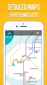




Paris Metro Map is a travel utility providing offline access to public transport navigation in Paris. It replaces traditional paper maps with a digital interface covering Metro, RER, Tram, Noctilien, and bus lines. The app is designed to assist tourists and commuters in navigating the city's transit network and sightseeing locations.
Overview · Full Intel report in progress
The App DNA
What makes this app unique?
For Travelers and commuters navigating the Paris public transport system.
What does it look like?
Key features
Provides access to transport lines without requiring an active internet connection.
Includes maps for Metro, RER, Tram, Noctilien, and bus lines, plus airport connections.
Features dedicated maps to help users locate and visit planned tourist sights.
How much does it cost?
Velocity
Dormant developmentShow more...
5 versions in history. Development pace: zombie.
Who built it?
Georgi Zlatinov
13+ apps tracked · Travel
 Multiple Photo Sets Timer
 Flashing Lights - Blue and Red
 Milan Metro and Transport
 Play Music On Multiple Devices
 Rock Paper Scissors.
 Camera Remote Control App
 Dog Whistle Sounds
 Sofia Metro Map.
 Barcelona - Sights and Maps
 Draww
Draww Truth or Dare Party Game
 DotsPop
User Sentiment
What do users think recently?
How are ratings & reviews evolving?
Not enough recent reviews to extract reliable themes yet.
Read the full review analysisCompetition
Competitive landscape for Paris Metro Map.
How's the Travel market?
The rivals identified
The Analyst's Read
Key takeaways for Paris Metro Map.
Where is it heading?
Bottom line
The app serves as a simple, offline-capable digital alternative to paper transit maps for navigating Paris.
Report last updated