


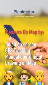


Planimeter GPS Area Measure is a mapping tool designed to calculate distance, area, and perimeter using manual input or GPS tracking. It supports data export in KML format and provides geo-coordinate tracking for professional and recreational land surveying tasks.
Overview · Full Intel report in progress
The App DNA
What makes this app unique?
For Professionals and hobbyists in fields such as construction, farming, real estate, and landscaping who require precise land and distance measurements.
What does it look like?
Key features
Calculates distance, area, and perimeter using both manual map plotting and real-time GPS tracking.
Allows users to label, save, and share measurement points in KML format.
Supports both Metric and Imperial units, including meters, kilometers, feet, yards, miles, hectares, and acres.
Provides current location search, bearing, and geo-coordinate data for specific site mapping.
How much does it cost?
Velocity
Maintenance developmentShow more...
5 versions in history. Development pace: maintenance.
Who built it?
VisTech.Projects
13+ apps tracked · Productivity
 Face Shape Meter camera tool
 Shoe Size Meter - feet length
 Distance and Height Telemeter
 Unit Converter | Converter4U
 PD Measure Ruler
 Planimeter 2 GPS area measure
 Millimeter Pro - screen ruler
 Pupillary Distance Measure
 Feet Meter measure shoe size
 Pupillary Distance Measure X
 Camera Measure - PartoMeter
 Spotlight on Picture
User Sentiment
What do users think recently?
How are ratings & reviews evolving?
Not enough recent reviews to extract reliable themes yet.
Read the full review analysisCompetition
Competitive landscape for Planimeter GPS Area Measure
How's the Productivity market?
The rivals identified
The Analyst's Read
Key takeaways for Planimeter GPS Area Measure
Where is it heading?
Bottom line
While the app offers robust measurement features, user feedback indicates potential issues with location accuracy and data persistence.
Report last updated