


PlanShot: LiDAR Floor Plans
By Aner Sarid


PlanShot: LiDAR Floor Plans is a mobile floor-plan generation tool for real estate and construction professionals, built on Apple's RoomPlan technology.
The App DNA
What makes this app unique?
The app removes the need for manual sketching and cloud-based processing, allowing field workers to finalize accurate floor plans while still on-site.
For Real estate agents, contractors, and property appraisers who require rapid, accurate floor plans for listings and estimates.
What does it look like?
Key features
Captures walls, doors, windows, and furniture using Apple's RoomPlan technology during a walk-through.
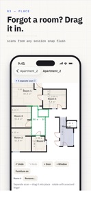
Allows users to drag walls and override dimensions with tape-measure data while scanning.
Performs all scanning, drawing, and exporting locally without requiring an internet connection.
How much does it cost?
The freemium model gates professional file formats and branding behind a Pro tier, offering a lifetime purchase option to lower long-term switching costs.
Velocity
Maintenance developmentnew contentmonetizationUX improvementsShow more...
The app maintains a maintenance-level cadence, with two releases shipped over the last two months. Development is currently focused on expanding professional utility and export capabilities for floor plan data. The latest release provides users with custom branding for exports and structured data output, indicating a stable, feature-driven development path rather than a high-frequency update cycle.
Who built it?
Aner Sarid
3 apps tracked · Productivity
 Practimo: Practice Tracker
 Practimo Tuner
User Sentiment
What do users think recently?
How are ratings & reviews evolving?
Not enough recent reviews to extract reliable themes yet.
Read the full review analysisCompetition
Competitive landscape for PlanShot: LiDAR Floor Plans
How's the Productivity market?
PlanShot: LiDAR Floor Plans operates in the Productivity category, focusing on professional-grade measurement tools. The app's value rests on its ability to provide offline, high-accuracy exports that compete directly with established CAD-integrated workflows.
Read the market outlookThe rivals identified
Unlock the deeper market read.
Access the full report for freeThe Analyst's Read
Key takeaways for PlanShot: LiDAR Floor Plans
Where is it heading?
The market for LiDAR-based measurement is shifting toward professional-grade integration, where simple scanning is no longer enough to retain users. PlanShot: LiDAR Floor Plans is well-positioned to capture this segment if it continues to build out workflow-specific tools like takeoff sheets.
- The latest release adds professional branding and CSV takeoff exports, demonstrating active feature investment rather than maintenance-only updates.
The SWOT
- On-site manual correction mechanism ensures high-fidelity output
- Offline-first architecture removes dependency on network connectivity
- Expanding CSV takeoff export to include material cost estimation
Next best moves
Ship material cost estimation in CSV takeoff export because contractors require budget data → increase Pro tier conversion
The counter-intuitive read
The app's offline-first design is a retention lever…
Read the full takeBottom line
PlanShot: LiDAR Floor Plans provides a high-accuracy alternative to manual measurement, but its success depends on capturing the contractor workflow beyond simple geometry. Integrating cost estimation would unlock higher-value professional adoption and differentiate the app from generic scanning tools.
Unlock 1 critical friction, 1 market threat and the analyst’s take.
Access the full report for freeFAQ
Is PlanShot: LiDAR Floor Plans accurate enough for professional appraisals?
Does PlanShot: LiDAR Floor Plans require an internet connection?
What file formats can I export from PlanShot: LiDAR Floor Plans?
Sources
- [1] App Store
Report last updated