



Terrafin Mobile provides anglers, divers, and researchers with mobile access to high-resolution satellite imagery, including sea surface temperature and chlorophyll charts. The app enables offline chart navigation, waypoint marking, and real-time GPS vessel tracking. It serves as a mobile extension of the Terrafin web platform, requiring an active subscription for current data access.
Overview · Full Intel report in progress
The App DNA
What makes this app unique?
For Marine professionals, recreational anglers, and researchers requiring satellite-based oceanographic data.
What does it look like?
Key features
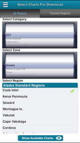
Allows users to download selected satellite charts for use without an active internet connection.
Provides cursor-based positioning with latitude, longitude, temperature readings, and distance/bearing calculations.
Displays the user's vessel location and movement track directly on the downloaded charts.
Delivers high-resolution sea surface temperature and chlorophyll/ocean color charts updated daily.
How much does it cost?
Velocity
Steady developmentShow more...
5 versions in history. Development pace: steady.
Who built it?
User Sentiment
What do users think recently?
How are ratings & reviews evolving?
Not enough recent reviews to extract reliable themes yet.
Read the full review analysisCompetition
Competitive landscape for Terrafin Mobile
How's the Weather market?
The rivals identified
The Analyst's Read
Key takeaways for Terrafin Mobile
Where is it heading?
Bottom line
While the app is free to download, it functions exclusively as a companion tool for users with an active $109/year Terrafin website subscription.
Report last updated