

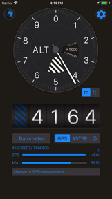

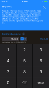

Altimeter+ is a navigation tool designed for outdoor enthusiasts to track altitude, elevation, and GPS coordinates. It utilizes a hybrid sensor approach, combining GPS triangulation, barometer pressure sensors, and network location services to provide data both online and offline.
Overview · Full Intel report in progress
The App DNA
What makes this app unique?
For Outdoor enthusiasts such as hikers, skiers, and mountain bikers who require precise elevation and location tracking.
What does it look like?
Key features
Measures altitude using GPS satellites, barometer pressure sensors, and online network services, either individually or in combination.
Provides accurate altitude measurements in meters or feet, including records for lowest and highest elevation points.
Displays full GPS coordinates including latitude and longitude, alongside current location name and state.
Includes an integrated compass tool to assist with orientation during outdoor activities.
How much does it cost?
Velocity
Maintenance developmentShow more...
5 versions in history. Development pace: maintenance.
Who built it?
Sichtwerk AG
3 apps tracked · Navigation
 Jagd-Lern App
 SaNa Fischerprüfung & Lexikon
User Sentiment
What do users think recently?
How are ratings & reviews evolving?
Not enough recent reviews to extract reliable themes yet.
Read the full review analysisCompetition
Competitive landscape for Altimeter+
How's the Navigation market?
The rivals identified
The Analyst's Read
Key takeaways for Altimeter+
Where is it heading?
Bottom line
The app offers a versatile, sensor-based approach to altitude and location tracking that functions independently of internet connectivity.
Report last updated