


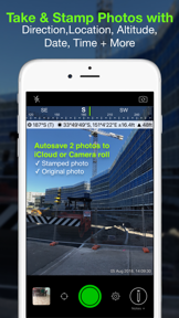


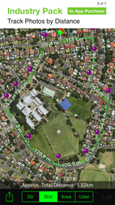


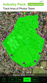
Solocator is a GPS-enabled field camera for iOS that stamps photos with location, bearing, and altitude data for professional documentation.
The App DNA
What makes this app unique?
Field professionals use the app to remove the manual friction of documenting site conditions, replacing fragmented notes with automated, verifiable photo evidence.
For Field professionals, including real estate appraisers, construction managers, and engineers.
What does it look like?
Key features
Stamps photos with location, bearing, altitude, and time data directly onto the image file.
Adds support for project notes, company logos, and custom export filenames via a one-off purchase.
Syncs original and stamped photos to Google Drive, Dropbox, and OneDrive.
How much does it cost?
Low-cost entry model with a one-time purchase avoids recurring subscription friction for professional users.
Velocity
Maintenance developmentUX improvementsperformanceShow more...
Solocator maintains a maintenance-level cadence, shipping 10 distinct versions over the observed window with an average of approximately 0.13 releases per week. Development is currently focused on UX improvements and platform-specific stability, particularly regarding OneDrive integration and camera capture reliability. The release trend has remained stable, prioritizing incremental refinements over major feature expansion since the latter half of 2025. The latest release occurred 115 days ago, consistent with the developer's pattern of infrequent, targeted updates.
Who built it?

User Sentiment
What do users think recently?
Review voice lately leans excited. Users appreciate construction and inspection professionals rely on the app for precise gps tagging and documentation in the field and responsive customer support provides personalized assistance that helps users resolve technical issues and operator errors. On the flip side, users report losing years of saved project photos and settings when restoring from backups or wiping devices.
How are ratings & reviews evolving?
What users say, by theme
- Construction and inspection professionals rely on the app for precise GPS tagging and documentation in the field
- Responsive customer support provides personalized assistance that helps users resolve technical issues and operator errors
- Offline functionality ensures that field data collection remains uninterrupted in remote areas without cellular connectivity
- Users report losing years of saved project photos and settings when restoring from backups or wiping devices
50 of 50 recent reviews analyzed · high confidence · Excited overall
Read the full review analysisUnlock 2 more frustration themes and 2 user requests, each backed by review evidence.
Access the full report for freeCompetition
Competitive landscape for Solocator - GPS Field Camera
How's the Navigation market?
Solocator maintains a consistent presence in the Navigation category, holding a #5 top paid rank in multiple markets. The gap between its high utility for field workers and the reported data-loss issues suggests a vulnerability to rivals offering more stable cloud-sync solutions.
Read the market outlookThe rivals identified

By Avenza Systems Inc.
Dominates the professional field mapping niche with a massive user base and specialized offline geospatial capabilities.
- Supports complex geospatial PDF imports that allow users to overlay custom maps for precise field navigation
- Provides a robust offline mapping engine that functions independently of cellular connectivity for remote fieldwork
- Offers a specialized store for purchasing professional-grade topographic and industry-specific maps directly within the app


Unlock the head-to-head verdict: where this rival wins, and where it loses.
Access the full report for freeThe Analyst's Read
Key takeaways for Solocator - GPS Field Camera
Where is it heading?
Users report: The professional field documentation market is consolidating around tools that offer both high-precision data and reliable cloud persistence. Solocator remains advantaged by its simple, single-purpose interface, but the lack of a robust sync mechanism leaves it exposed to competitors that prioritize data integrity over feature breadth.
- Recurring reports of data loss during device migrations erode professional trust, which compounds the churn pressure from more stable mapping rivals.
- Responsive customer support helps resolve hardware-specific conflicts, maintaining a core base of construction and inspection professionals who rely on the app.
The SWOT
- Offline-first design ensures data collection continuity in remote areas.
- Precise metadata stamping establishes category authority for professional photo evidence.
- Native video support with live GPS tracking would satisfy top user requests.
- Robust cloud-sync implementation would mitigate the primary churn risk.
Next best moves
Ship reliable cloud-sync migration because data loss is the top churn driver → improve retention
+ 1 more prioritized moveThe counter-intuitive read
The app's reliance on one-off payments is a retention strength, not a weakness…
Read the full takeFeature gaps
Complex geospatial PDF imports (available in Avenza Maps) +1
Since the last report: Cloud Autosave integration marks the most consequential update, directly targeting the previously identified data-loss churn risk. Despite this addition, the app's competitive position remains constrained by persistent user reports of backup failures and monetization friction.
Bottom line
Solocator's core GPS-tagging utility retains a loyal professional base, but the recurring data-loss complaints undermine its value as a professional documentation tool. Prioritizing a reliable cloud-sync mechanism would secure the app's position against more stable, albeit more complex, mapping rivals.
Unlock 2 critical frictions, 2 market threats, 1 more prioritized move and the analyst’s take.
Access the full report for freeFAQ
Is Solocator suitable for professional surveying?
How does Solocator compare to Avenza Maps?
Does Solocator work without an internet connection?
Sources
- [1] App Store listing, source
Report last updated