


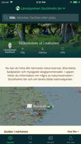
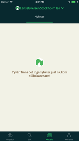


Stockholms läns Naturkarta is a regional travel guide for nature reserves and national parks in Stockholm, providing maps and facility information on iOS.
The App DNA
What makes this app unique?
It removes the friction of planning outdoor trips by centralizing municipal data on trail conditions and infrastructure, which displaces the need for fragmented government websites.
For Outdoor enthusiasts and hikers in the Stockholm region seeking localized information on nature reserves and national parks.
What does it look like?
Key features
Interactive map interface displaying nature reserves and trails using Mapbox and OpenStreetMap data.
Visual markers for infrastructure including toilets and parking, reducing visitor friction.
User-generated discussion threads linked to specific locations for information exchange.
How much does it cost?
The app operates as a free public service tool funded by municipal and regional government partnerships rather than direct consumer monetization.
Velocity
Dormant developmentopaqueShow more...
Stockholms läns Naturkarta has been inactive for 291 days, falling well outside the threshold for active development. The last release consisted solely of minor bug fixes and performance improvements. There is no evidence of ongoing feature development or operational support, characterizing the app as a zombie project.
Who built it?
Outdoormap AB
5 apps tracked · Travel
 Norrbottens Naturkarta
 Naturkartan
 Naturkartan
 ARK56
ARK56User Sentiment
What do users think recently?
How are ratings & reviews evolving?
Not enough recent reviews to extract reliable themes yet.
Read the full review analysisCompetition
Competitive landscape for Stockholms läns Naturkarta
How's the Travel market?
Stockholms läns Naturkarta functions as a regional utility, holding a stable position as a government-backed information source. The lack of recent updates suggests a focus on maintenance rather than chart-driven growth.
Read the market outlookThe rivals identified
Unlock the deeper market read.
Access the full report for freeThe Analyst's Read
Key takeaways for Stockholms läns Naturkarta
Where is it heading?
The regional nature-guide market is stable, but Stockholms läns Naturkarta is currently in a maintenance phase. The lack of feature expansion over the last nine months suggests the app will remain a static utility rather than a growing platform, which may lead to gradual churn as users migrate to more frequently updated mapping tools.
- The nine-month development gap indicates a maintenance-only posture, which limits the ability to respond to changing user needs.
- The integration of facility-specific markers provides a clear utility that general-purpose maps often overlook, sustaining the app's core value.
The SWOT
- Government-backed data accuracy provides a distribution barrier against generic rivals
- Facility-specific mapping reduces visitor friction during active excursions
- Integration of real-time public transport data to simplify access to remote reserves
Next best moves
Audit current user-generated content moderation because the community Q&A feature is a unique differentiator → maintain trust and safety
The counter-intuitive read
The app's lack of commercial monetization is its primary strength…
Read the full takeBottom line
Stockholms läns Naturkarta provides essential utility for regional hikers, but the maintenance-only cadence risks obsolescence as general mapping platforms expand their trail data. Focusing on the community-driven information loop would unlock higher retention than simple map updates.
Unlock 2 critical frictions, 1 market threat and the analyst’s take.
Access the full report for freeFAQ
Is Stockholms läns Naturkarta free to use?
Does the app work offline?
How does this compare to Google Maps?
Sources
- [1] Developer website, source
Report last updated