


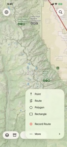

Treeline Maps: Topo & Trails is a navigation app for North American hikers, offering offline topographic maps and specialized wilderness data layers on iOS.
The App DNA
What makes this app unique?
The app removes the reliance on cellular connectivity for wilderness navigation, allowing users to access detailed terrain data in remote areas where standard maps fail.
For Outdoor enthusiasts and hikers in North America requiring detailed topographic data and offline navigation.
What does it look like?
Key features
NPS-inspired cartography creates a visual barrier to entry, increasing user switching costs.
Downloadable map packs remove cellular dependency, ensuring utility in remote wilderness.
Calculates visible terrain from specific coordinates to assist in trip planning.
How much does it cost?
Treeline Maps: Topo & Trails is currently free with no visible subscription or IAP gates, limiting long-term revenue potential.
Velocity
Maintenance developmentUX improvementsShow more...
The app currently operates at a maintenance cadence, with only one release shipped in the last 43 days. Development is focused exclusively on UX improvements, specifically refining the interface for point and feature selection. There is no evidence of a shift toward live operations or a high-velocity feature release cycle. The current pace suggests a stable, low-frequency update schedule focused on incremental usability adjustments.
Who built it?
User Sentiment
What do users think recently?
How are ratings & reviews evolving?
Not enough recent reviews to extract reliable themes yet.
Read the full review analysisCompetition
Competitive landscape for Treeline Maps: Topo & Trails
How's the Navigation market?
Treeline Maps: Topo & Trails occupies a niche position in the Navigation category as a free, specialized tool for North American wilderness mapping. The absence of monetization signals a focus on user acquisition over immediate revenue generation.
Read the market outlookThe rivals identified
Unlock the deeper market read.
Access the full report for freeThe Analyst's Read
Key takeaways for Treeline Maps: Topo & Trails
Where is it heading?
The wilderness navigation market is consolidating around apps that offer both high-fidelity offline data and sustainable subscription models. Treeline Maps: Topo & Trails remains exposed due to its lack of monetization, which will eventually force a pivot to paid tiers to fund the development required to maintain parity with larger competitors.
- The maintenance-only update cadence suggests a focus on stability over rapid feature expansion, which limits the ability to respond to market shifts.
The SWOT
- NPS-inspired cartography increases user switching costs
- Offline map packs remove cellular dependency
- Viewshed generation assists in trip planning
- Localized trail data expansion could capture underserved segments
Next best moves
Implement a freemium model because current free-only pricing limits revenue potential → increase long-term sustainability
The counter-intuitive read
The lack of monetization is not a weakness…
Read the full takeSince the last report: The app remains in a maintenance-only state with no changes to features or pricing. The primary shift is a more nuanced framing of the product's lack of monetization in the SWOT and contrarian analysis.
Bottom line
Treeline Maps: Topo & Trails provides high-utility offline mapping, but the lack of monetization creates a sustainability risk. Introducing a tiered model would unlock revenue to support the development cadence required to compete with established navigation rivals.
Unlock 2 critical frictions, 1 market threat and the analyst’s take.
Access the full report for freeFAQ
Is Treeline Maps: Topo & Trails free to use?
Does Treeline Maps: Topo & Trails work without internet?
What areas does Treeline Maps cover?
Sources
- [1] App Store, source
Report last updated