


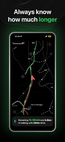


Trekx is an offline hiking navigation app for iOS that provides real-time pace-based arrival estimates and topographic map data.
The App DNA
What makes this app unique?
It removes the cognitive and battery-related friction of manual navigation in remote areas where cellular connectivity is absent.
For Hikers and outdoor enthusiasts who prioritize safety, offline reliability, and battery efficiency over social networking features.
What does it look like?
Key features
Calculates real-time arrival estimates based on user pace, providing safety warnings against sunset.
Displays distance, time, and elevation directly on the lock screen to reduce friction.
Downloads high-contrast topographic and satellite data for use without cellular signal.
How much does it cost?
Trekx operates as a non-monetized utility, which removes the barrier to entry but limits the capital available for feature expansion.
Velocity
Maintenance developmentperformanceShow more...
Trekx: Offline Hiking Maps operates on a maintenance cadence, with the latest release occurring 49 days ago. The development history shows only a single version update within the observed window, which focused exclusively on minor optimizations. There is no evidence of new feature development or live operations, indicating a focus on stability rather than growth. The current release frequency suggests a stable but slow development cycle.
Who built it?
User Sentiment
What do users think recently?
How are ratings & reviews evolving?
Not enough recent reviews to extract reliable themes yet.
Read the full review analysisCompetition
Competitive landscape for Trekx: Offline Hiking Maps
How's the Health & Fitness market?
Trekx occupies a specialized safety-first niche in the Health & Fitness category. The lack of monetization and social features differentiates it from broader hiking apps, though the 49-day gap since the latest update signals a maintenance-focused posture.
Read the market outlookThe rivals identified
Unlock the deeper market read.
Access the full report for freeThe Analyst's Read
Key takeaways for Trekx: Offline Hiking Maps
Where is it heading?
The hiking navigation market is shifting toward social-discovery features, which creates a consolidation risk for solo-utility apps. Trekx remains advantaged by its zero-cost, offline-first design, but the lack of feature expansion leaves it exposed to rivals that offer broader trail coverage.
- The maintenance-only release cadence indicates a stable, feature-complete product that avoids the bloat of social-focused hiking rivals.
- The focus on offline-first safety tools creates a defensible niche against ad-supported rivals that require constant connectivity.
The SWOT
- OLED-optimized interface reduces battery drain during multi-day hikes
- Real-time pace-based arrival estimates provide a safety mechanism against unexpected sunset
- Localized trail data expansion in regions where the Italian Alpine Club (CAI) standards are recognized
Next best moves
Audit trail data coverage because the current reliance on CAI-verified estimates limits geographic expansion → increase user base
The counter-intuitive read
The lack of social features is a retention lever, not a weakness…
Read the full takeSince the last report: The app's competitive positioning has shifted from a generic safety utility to a specialized tool leveraging Italian Alpine Club (CAI) verification standards for its pace-based arrival estimates.
Bottom line
Trekx maintains a niche position by prioritizing battery efficiency and offline safety over social features. The lack of recent feature expansion suggests the current toolset is stable, but the developer must monitor rival feature parity to avoid being displaced by more active competitors.
Unlock 1 critical friction, 1 market threat and the analyst’s take.
Access the full report for freeSources
- [1] App Store, source
Report last updated