



TrueStamp: GPS Map Camera is a utility for field professionals to create geotagged, timestamped photo documentation on iOS.
The App DNA
What makes this app unique?
The app removes the friction of manual site logging by automating the embedding of location and time data into field images.
For Field professionals in construction, logistics, and agriculture requiring verifiable, geotagged documentation.
What does it look like?
Key features
Saves an untouched original photo alongside the stamped version to preserve raw image data.
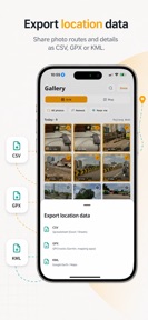
Generates PDF reports and exports data in CSV, GPX, and KML formats.
Uses last known location data to stamp images in low-signal rural environments.
How much does it cost?
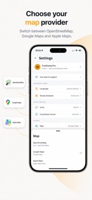
Freemium model gates advanced export formats, map providers, and ad-removal behind a Pro subscription.
Velocity
Active developmentUX improvementsperformanceShow more...
TrueStamp maintains an active development pace, shipping two updates within the last 30 days. The latest release focuses on resolving specific functional bugs related to location permission handling and automatic photo saving. Development is currently centered on UX improvements and stability, ensuring core features like GPS tagging and library integration perform reliably. The team is consistently addressing user-reported technical friction with a cadence of approximately one release every two weeks.
Who built it?
ACKPlus Solutions Private
4 apps tracked · Photo & Video
 EMI Calculator Loan & Interest
 Expiry Guard: Doc Reminder
 Wordy: Word Search Puzzle
User Sentiment
What do users think recently?
How are ratings & reviews evolving?
Not enough recent reviews to extract reliable themes yet.
Read the full review analysisCompetition
Competitive landscape for TrueStamp: GPS Map Camera
How's the Photo & Video market?
TrueStamp: GPS Map Camera occupies a specialized niche in the Photo & Video category, focusing on professional documentation rather than social sharing. The current release cadence (two updates in the last month) suggests active development aimed at professional-grade reliability.
Read the market outlookThe rivals identified
Unlock the deeper market read.
Access the full report for freeThe Analyst's Read
Key takeaways for TrueStamp: GPS Map Camera
Where is it heading?
The market for field-documentation tools is shifting toward integrated reporting, and TrueStamp: GPS Map Camera is well-positioned if it can maintain its technical reliability. Consistent updates suggest the developer is prioritizing the core utility, which will be critical for retaining professional users as competition increases.
- The consistent release cadence (two updates in the last month) signals active investment in professional-grade reliability.
- The focus on stability in the latest release addresses core location-tracking needs, which is essential for maintaining trust in field-proof documentation.
The SWOT
- Dual-capture mechanism preserves raw EXIF data for audit-ready documentation
- Offline geocoding enables consistent data collection in remote rural sites
- Localized support for 15 languages provides a distribution barrier into international government and agricultural surveys
Next best moves
Publish Pro-tier pricing on the website because lack of transparency creates procurement friction → increase enterprise conversion
The counter-intuitive read
The app's offline-first design is a retention lever…
Read the full takeSince the last report: The report reflects a strategic pivot toward enterprise-grade positioning, emphasizing audit-ready data integrity and addressing procurement friction through clearer pricing communication.
Bottom line
TrueStamp: GPS Map Camera provides a specialized utility for field documentation, and clarifying Pro-tier pricing would unlock enterprise adoption by removing procurement friction.
Unlock 1 critical friction, 1 market threat and the analyst’s take.
Access the full report for freeFAQ
Is TrueStamp: GPS Map Camera suitable for professional site inspections?
Does TrueStamp: GPS Map Camera work without an internet connection?
What features are included in the Pro version?
Sources
- [1] App Store listing, source
Report last updated