


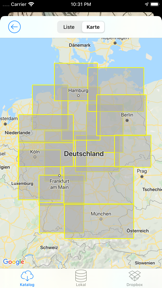


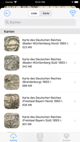
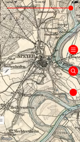
Vetus Maps is a navigation tool designed to help users locate historical sites by overlaying antique maps onto modern satellite, hybrid, and terrain views. It serves as a digital resource for local historians and antiquity enthusiasts to track lost toponyms and geographical changes over time.
Overview · Full Intel report in progress
The App DNA
What makes this app unique?
For The primary audience consists of local historians, researchers, and hobbyists interested in historical geography and archaeology.
What does it look like?
Key features
Allows users to superimpose historical maps onto modern satellite, hybrid, or terrain map layers.
Provides adjustable transparency settings to facilitate precise alignment between historical and contemporary map data.
Includes functionality for setting custom markers and recording GPS tracks during exploration.
Offers a library of historical maps covering various districts and provinces for offline access.
How much does it cost?
Velocity
Who built it?
Andrey Fetisov
13+ apps tracked · Navigation
 Охотничий манок на утку
 Охотничий манок на гуся
 Georgian driver license test
 Muslim Prayer Adhan Times
 100 US Citizenship Test Questions 2017
 Pulsometr - Heart Rate Monitor
 PHQ-9 Depression Test Questionnaire
 ПДД 2026 Билеты и Экзамен
 California DMV Driving Knowledge Test - Exam 2017
 Avto Imtahan - Azərbaycan Yol Hərəkəti Qaydaları
 British Columbia, Canada Driver Knowledge Test
 Ontario G1 Driving Theory Test Free
User Sentiment
What do users think recently?
How are ratings & reviews evolving?
Not enough recent reviews to extract reliable themes yet.
Read the full review analysisCompetition
Competitive landscape for Vetus Maps
How's the Navigation market?
The rivals identified
The Analyst's Read
Key takeaways for Vetus Maps
Where is it heading?
Bottom line
Vetus Maps provides a specialized utility for historical research by enabling the visual comparison of antique cartography with modern navigation data.
Report last updated