




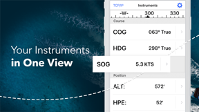


iNavX is a handheld marine navigation tool that provides worldwide chart coverage and real-time data integration for sailors and boaters. The app distinguishes itself by offering access to a broad range of third-party chart providers and professional-grade weather forecasting tools.
Overview · Full Intel report in progress
The App DNA
What makes this app unique?
For Recreational sailors and boaters requiring mobile access to marine charts, weather forecasts, and AIS tracking.
What does it look like?
Key features
Provides access to a wide library of marine charts including iNavX Professional+, Blue Latitude, and Explorer.
Supports AIS overlays and GRIB weather forecasts to assist with route planning and proactive sail management.
Allows users to plan sailing routes and manage waypoints directly within the interface.
Delivers real-time data on boating conditions, including currents and wind forecasts.
How much does it cost?
Velocity
Steady developmentShow more...
5 versions in history. Development pace: steady.
Who built it?
User Sentiment
What do users think recently?
How are ratings & reviews evolving?
Not enough recent reviews to extract reliable themes yet.
Read the full review analysisCompetition
Competitive landscape for iNavX: Marine Navigation
How's the Navigation market?
The rivals identified

By savvy navvy
Both apps target recreational sailors and boaters with freemium marine navigation tools, creating direct competition for users seeking chart access and weather forecasting.
- Savvy Navvy provides automated route planning based on depth and weather, while iNavX requires manual waypoint management.
- Savvy Navvy prioritizes a clutter-free interface, whereas iNavX offers access to a wider range of third-party chart providers.
 C-MAP: BoatingContender
 Navionics® BoatingContender
 TZ iBoat – Marine NavigationContender
 Orca: Boat GPS, Charts, RoutesContender
 Aqua Map BoatingContender
 i-Boating: Marine Charts & GpsContender
 Argo - Boating NavigationContender
 ActiveCaptain®Contender

Unlock the head-to-head verdict: where this rival wins, and where it loses.
Access the full report for freeThe Analyst's Read
Key takeaways for iNavX: Marine Navigation
Where is it heading?
Bottom line
While the app offers comprehensive navigation features and extensive chart support, users frequently report significant friction regarding subscription management, interface usability, and intrusive advertising.
Report last updated