


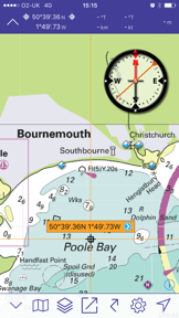

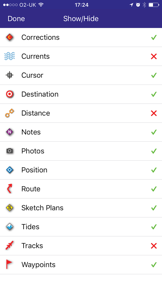


Imray Navigator is a marine chart plotter designed for sailors, divers, and fishermen to facilitate passage planning and navigation. It provides access to award-winning raster charts and integrates real-time data such as GPS, AIS, and NMEA functionality. The app distinguishes itself by offering quarterly updates through a subscription model to ensure users have the latest hydrographic data.
Overview · Full Intel report in progress
The App DNA
What makes this app unique?
For Marine enthusiasts and professionals involved in navigation, including sailors, divers, and fishermen.
What does it look like?
Key features
Provides access to award-winning nautical charts from Imray and various Hydrographic Offices.
Enables users to create routes with specific targets, bearings, and distance calculations.
Supports GPS, AIS, NMEA functionality, and tide data via the Tides Planner app.
Offers an auto-renewable 12-month subscription that includes quarterly chart editions, notes, and corrections.
How much does it cost?
Velocity
Intense developmentShow more...
5 versions in history. Development pace: intense.
Who built it?
FB Imray Laurie Norie & Wilson
6 apps tracked · Navigation
 Marine Rules & Signals
 Boat Instruments
 Marine Chart Symbols
 Explore with Imray
 Tides Planner
User Sentiment
What do users think recently?
How are ratings & reviews evolving?
Not enough recent reviews to extract reliable themes yet.
Read the full review analysisCompetition
Competitive landscape for Imray Navigator
How's the Navigation market?
The rivals identified

By Nobeltec, Inc.
Both apps target the same marine navigation segment, competing for sailors and fishermen who require reliable chart plotting and route planning tools.
- TZ iBoat integrates high-resolution bathymetry and satellite data, whereas Imray Navigator relies on raster charts.
- TZ iBoat provides cloud synchronization for routes across multiple devices, a feature absent in Imray Navigator.
- TZ iBoat offers an offline-first architecture for offshore reliability, while Imray Navigator requires active subscription management.
 Navionics® BoatingContender
 Orca: Boat GPS, Charts, RoutesContender
 Nautical Charts & MapsContender
 Wärtsilä iSailorContender
 iNavX: Marine NavigationContender
 NavilyContender
 i-Boating: Marine Charts & GpsContender
 B&G: Companion App for SailorsContender

Unlock the head-to-head verdict: where this rival wins, and where it loses.
Access the full report for freeThe Analyst's Read
Key takeaways for Imray Navigator
Where is it heading?
Bottom line
While the app offers comprehensive navigation features, users report significant friction regarding subscription activation and chart downloads.
Report last updated