




Polaris® is a navigation app for off-road and snow trail enthusiasts, providing offline maps and vehicle maintenance tracking on iOS and Android.
The App DNA
What makes this app unique?
Users hire Polaris® to coordinate group rides and manage powersports vehicle maintenance in remote areas where cellular connectivity is unreliable.
For Off-road and powersports vehicle owners who require navigation, vehicle maintenance tracking, and social connectivity in remote areas.
What does it look like?
Key features
Real-time location tracking and messaging for riders in a group, including offline visibility of last known positions. Revenue link: Community network effect increases retention by creating social dependency on the platform for group coordination.
Downloadable map packs covering over 1.3 million miles of trails for navigation without cellular service. Revenue link: Brand moat removes connectivity dependency rivals require, reinforcing category authority for off-road navigation.
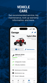
Digital storage for vehicle service history, maintenance schedules, and service appointment scheduling. Revenue link: B2B partnership drives traffic to RideReady service appointments and OEM-authorized maintenance channels.
How much does it cost?
Freemium model leverages free app access to drive hardware ecosystem adoption, with RIDE COMMAND+ serving as a recurring revenue layer for remote vehicle services.
Velocity
Intense developmentShow more...
5 versions in history. Development pace: intense.
Who built it?
Polaris Industries
3 apps tracked · Navigation
 Slingshot®
 Indian Motorcycle®
User Sentiment
What do users think recently?
Fresh user feedback skews mixed. Users appreciate offline map functionality allows riders to navigate remote areas without reliable cellular data connectivity and three-dimensional flyover features provide an immersive way for off-road enthusiasts to visualize their trail routes.
How are ratings & reviews evolving?
What users say, by theme
- Offline map functionality allows riders to navigate remote areas without reliable cellular data connectivity
- Three-dimensional flyover features provide an immersive way for off-road enthusiasts to visualize their trail routes
- Ride tracking and performance statistics offer valuable post-ride insights for motorsports and powersports enthusiasts
- Frequent application freezing and crashes during ride recording sessions disrupt the user experience for many riders
49 of 49 recent reviews analyzed · high confidence · Mixed overall
Read the full review analysisUnlock 2 more frustration themes and 2 user requests, each backed by review evidence.
Access the full report for freeCompetition
Competitive landscape for Polaris®
How's the Navigation market?
Polaris® currently sits #93 Free in the US category. The app's specialized focus on powersports maintenance differentiates it from generalist navigation tools, though the #93 rank indicates significant room for growth in the broader navigation market.
Read the market outlookThe rivals identified

By TrailBehind
Dominates the outdoor navigation space with a massive user base and a mature feature set that serves as the industry benchmark for trail planning.
- Offers a comprehensive library of professional-grade map layers including public land and private property boundaries
- Provides advanced offline map downloading capabilities that function reliably in remote areas without cellular service
- Supports complex route planning with custom waypoints and elevation profiles for serious backcountry navigation
 Wikiloc - Trails of the WorldContender
 Avenza Maps: Offline MappingContender
 calimoto Motorcycle NavigationContender
Unlock the head-to-head verdict: where this rival wins, and where it loses.
Access the full report for freeThe Analyst's Read
Key takeaways for Polaris®
Where is it heading?
The powersports navigation market is consolidating around high-utility, community-driven platforms. Polaris® remains advantaged by its OEM-authorized maintenance integration, but the current technical instability leaves it exposed to churn, so the team must stabilize the core recording engine to defend its market share against Gaia GPS.
- Frequent crashes during ride recording sessions erode user trust, which compounds the churn risk against stable competitors like Gaia GPS.
- Offline map functionality remains a strong retention lever, as it allows riders to navigate remote areas without cellular data connectivity.
The SWOT
- Offline map packs remove the connectivity dependency rivals require
- Vehicle-specific maintenance schedules drive OEM-authorized service traffic
- Integration with vehicle display systems to mirror navigation screens
- Improved selection tools for managing overlapping tracks in dense areas
Next best moves
Rebuild ride recording session logic because crashes are the top-reported frustration theme → increase session retention.
+ 1 more prioritized moveThe counter-intuitive read
The app's stability issues are a feature-set distraction…
Read the full takeFeature gaps
Professional-grade map layers including public land boundaries (available in Gaia GPS but missing here) +1
Since the last report: Users report: The report reflects a shift toward more detailed feature and sentiment tracking, revealing critical stability issues in ride recording that were previously generalized.
Bottom line
Polaris® secures its position through unique OEM-authorized maintenance integration, but persistent stability regressions during ride recording erode user trust, so the team must prioritize core navigation reliability over new feature development to prevent churn to Gaia GPS.
Unlock 2 critical frictions, 2 market threats, 1 more prioritized move and the analyst’s take.
Access the full report for freeFAQ
Is Polaris® good for off-road navigation?
How does Polaris® compare to Gaia GPS?
Does Polaris® work without cellular service?
What are the best alternatives to Polaris®?
Sources
Report last updated