




FeatureMapper is a GPS-based field data collection tool for utility and environmental workers, available as a paid iOS application.
The App DNA
What makes this app unique?
Users hire FeatureMapper for simple, lightweight KML placemarking in the field, avoiding the complexity of full-scale GIS software.
For Utility workers, tree trimming companies, and environmental consultants requiring field-based GPS data collection.
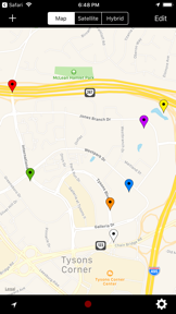
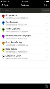
What does it look like?
Key features
Records location, name, comment, and color-coded markers for field data points.
Captures Placemarks at user-defined time intervals in foreground or background modes.
Displays latitude and longitude in decimal, DMS, and UTM formats.
Packages datasets as KML email attachments for external GIS software integration.
How much does it cost?
Paid model at $9.99 USD targets professional field service users with a one-time license.
Velocity
Dormant developmentplatform expansionShow more...
The app has not received a release in over 15 months, falling well outside the threshold for active development. With only a single version provided in the history, there is no evidence of ongoing maintenance or feature updates. The development status is classified as zombie due to the lack of activity since early 2025.
Who built it?
FTLapps
8 apps tracked · Navigation
 TrackDay for iPhone
 ColorAssist Lite
 ColorAssist
 EveryDay Do It All
 ZenConnect
 TrackDay Pro
 AgileCards Lite
User Sentiment
What do users think recently?
How are ratings & reviews evolving?
Not enough recent reviews to extract reliable themes yet.
Read the full review analysisCompetition
Competitive landscape for FeatureMapper
How's the Navigation market?
FeatureMapper operates as a niche, paid-utility tool in the Navigation category, holding a 5-star rating on a single review. The $9.99 price point positions it against free, feature-rich competitors, creating a barrier to entry for casual field users.
Read the market outlookThe rivals identified

By Avenza Systems Inc.
Avenza dominates the professional field data collection niche with a massive user base and specialized support for geospatial PDF and KML workflows.
- Supports professional-grade geospatial PDF imports which target app lacks for complex site planning
- Offers a robust store for purchasing specialized third-party maps beyond basic GPS coordinates
- Provides advanced layer management tools for complex utility and environmental site documentation

Unlock the head-to-head verdict: where this rival wins, and where it loses.
Access the full report for freeThe Analyst's Read
Key takeaways for FeatureMapper
Where is it heading?
The navigation utility market is consolidating around high-frequency update cadences and community-driven features. FeatureMapper remains a static, professional-grade tool, which risks obsolescence as competitors integrate broader mapping context and simplified address systems.
- The app maintains a stable, single-purpose utility, but the lack of recent feature updates limits growth against more active navigation competitors.
The SWOT
- Focused, lightweight interface reduces cognitive load
- Automated background recording enables hands-free collection
- Develop B2B partnerships for bulk licensing
- Introduce freemium tier for casual users
Next best moves
Introduce a freemium tier because the $9.99 price point limits user acquisition against free competitors → increase top-of-funnel conversion.
The counter-intuitive read
The app's lack of updates is not a failure of maintenance…
Read the full takeFeature gaps
Offline map-layering (available in Avenza Maps but missing here) +1
Since the last report: The app remains in a zombie development state, but the strategic outlook has shifted to prioritize a freemium model to address competitive pricing pressure.
Bottom line
FeatureMapper provides a focused, lightweight KML collection tool, but its $9.99 price point and lack of feature updates leave it exposed to free, map-heavy competitors, so the PM should pivot to a freemium model to capture casual field-service users.
Unlock 3 critical frictions, 3 market threats and the analyst’s take.
Access the full report for freeReport last updated