


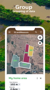

GLandMeasure is a GPS-based land and field area measurement tool for farmers, real estate agents, and surveyors on iOS and Android.
The App DNA
What makes this app unique?
Users hire this tool to quickly calculate property boundaries and land volume without needing complex GIS software, so the app must balance simple UI with professional export utility.
For Farmers, land surveyors, real estate agents, and property owners requiring precise field measurements and GIS data.
What does it look like?
Key features
Calculates land area and distance by pinning points on a map or tracking movement via GPS.
Exports survey data into KML, GeoJSON, CSV, Excel, and PDF formats.
Captures georeferenced photos to document specific points of interest within a project.
How much does it cost?
The app operates on an ad-supported model, targeting high-volume usage from professional and casual land surveyors.
Velocity
Maintenance developmentnew contentUX improvementsplatform expansionShow more...
The app exhibits a maintenance-level cadence, with only two releases identified in the recent window. While the latest version on Android represents a significant feature expansion, the overall frequency of updates is sparse. Development is currently focused on expanding core measurement tools and platform-specific utility. The disparity between platforms suggests a non-synchronized development cycle.
Who built it?
User Sentiment
What do users think recently?
Fresh user feedback skews thrilled. Users appreciate accurate gps land measurement tools provide reliable data for professional surveyors and real estate agents and simple interface design allows users to perform quick land calculations without complex technical training, but report inability to share measurement files between different mobile devices hinders collaborative field work for teams.
How are ratings & reviews evolving?
Weekly average review rating
What users say, by theme
- Accurate GPS land measurement tools provide reliable data for professional surveyors and real estate agents
- Simple interface design allows users to perform quick land calculations without complex technical training
- Inability to share measurement files between different mobile devices hinders collaborative field work for teams
54 of 54 recent reviews analyzed · high confidence · Thrilled overall
Read the full review analysisUnlock 2 more frustration themes and 1 user request, each backed by review evidence.
Access the full report for freeCompetition
Competitive landscape for GLand: GPS Field Area Measure
How's the Utilities market?
GLandMeasure maintains a 4.58-star rating across 598 iOS reviews, positioning it as a reliable utility for field measurements. The lack of cross-device sync limits its grossing potential compared to professional-grade GIS software that supports team collaboration.
Read the market outlookThe rivals identified
Unlock the deeper market read.
Access the full report for freeThe Analyst's Read
Key takeaways for GLand: GPS Field Area Measure
Where is it heading?
The field-measurement market is consolidating around tools that offer seamless team collaboration, leaving GLandMeasure exposed if it remains a single-device utility. While the recent addition of KML and GeoJSON support shows strong feature velocity, the lack of cloud-sync will likely compress the professional user funnel by Q1.
- Inconsistent GPS location tracking causes measurement errors, which erodes user trust and drives churn toward more stable professional-grade GIS alternatives.
- The latest release added KML and GeoJSON import support, demonstrating active feature investment rather than maintenance-mode stagnation.
The SWOT
- Multi-format data export functions as a B2B distribution barrier into real estate workflows
- GPS-based area calculation provides a low-barrier entry for casual property owners
- Spanish language localization could capture a significant non-English speaking user segment
Next best moves
Ship cross-device cloud sync because file-sharing friction is the #1 team-collaboration complaint → reduce churn among professional surveyors
+ 1 more prioritized moveThe counter-intuitive read
The app's ad-supported model is a strategic advantage, not a weakness…
Read the full takeSince the last report: The report reflects a shift toward a more defensive competitive stance, highlighting that technical GPS instability and lack of collaboration are now actively driving churn.
Bottom line
GLandMeasure secures its position through versatile export formats, but the lack of cloud-based project sharing and GPS instability threatens its professional-user base, so the product team should prioritize cross-device sync to defend against specialized GIS rivals.
Unlock 3 critical frictions, 1 market threat, 1 more prioritized move and the analyst’s take.
Access the full report for freeSources
- [1] App Store, source
Report last updated