


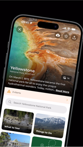
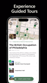
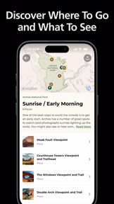

The National Park Service app provides interactive maps, self-guided tours, and offline content for 420+ national parks on iOS and Android.
The App DNA
What makes this app unique?
It removes the friction of navigating remote areas without cellular coverage, serving as the official, reliable resource for park visitors.
For National park visitors and outdoor enthusiasts seeking navigation, educational content, and trip planning tools.
What does it look like?
Key features
Download maps and park information for use in areas without cellular connectivity.
Audio-supported tours of park highlights and historical sites.
Scans user photos to detect and map previously visited national parks.
How much does it cost?
The app is a free public service provided by the U.S. government with no monetization or paid tiers.
Velocity
Maintenance developmentnew contentUX improvementsperformanceShow more...
The development cadence is currently in a maintenance phase, with 3 releases over the observed window and the most recent update occurring 104 days ago. Recent efforts have focused on expanding trail and transit data, alongside infrastructure improvements for low-data environments. While the latest release introduced new beta features, the overall frequency of updates has slowed, indicating a stable but infrequent development cycle. The team continues to balance feature expansion with performance and stability refinements.
Who built it?

User Sentiment
What do users think recently?
Recent user voice shows a thrilled sentiment. Users appreciate offline map and data downloads provide essential utility for visitors in remote areas without cellular coverage and audio-guided walking tours provide an informative and immersive experience for visitors exploring historical park sites, but report map download failures and unresponsive touch controls hinder navigation for users during active park visits.
How are ratings & reviews evolving?
What users say, by theme
- Offline map and data downloads provide essential utility for visitors in remote areas without cellular coverage
- Audio-guided walking tours provide an informative and immersive experience for visitors exploring historical park sites
- The interface provides a clear and intuitive structure for planning trips across multiple national park locations
- Map download failures and unresponsive touch controls hinder navigation for users during active park visits
79 of 99 recent reviews analyzed · high confidence · Thrilled overall
Read the full review analysisUnlock 1 more frustration theme and 1 user request, each backed by review evidence.
Access the full report for freeCompetition
Competitive landscape for National Park Service
How's the Travel market?
The app maintains a 4.8+ rating across both platforms, signaling strong user satisfaction with its core utility. Its position as the official government resource provides a unique barrier to entry that commercial travel apps cannot match.
Read the market outlookThe rivals identified

By Chimani, Inc.
The most direct mirror to the NPS app, offering comprehensive guides, maps, and a gamified 'check-in' system for all 400+ U.S. National Park units.
- Gamified 'Virtual Badges' and points system for visiting parks and recording activities
- Curated 'Chimani Perks' offering discounts on nearby lodging and activities
- Unified interface that aggregates news and alerts across the entire park system in a single feed


Unlock the head-to-head verdict: where this rival wins, and where it loses.
Access the full report for freeThe Analyst's Read
Key takeaways for National Park Service
Where is it heading?
The travel app market is consolidating around high-utility, offline-capable tools. The National Park Service app remains advantaged by its official status, but technical stability is now the primary bottleneck for growth and retention.
- Persistent map download failures in the latest version erode user trust during critical park visits, which compounds the risk of churn to third-party tools.
- The introduction of beta trail browsing shows active feature investment, which keeps the app relevant against commercial travel guides.
The SWOT
- Official government mandate provides authoritative data
- Offline-first architecture functions as a defensible barrier
- Unified map view for all parks simultaneously
Next best moves
Rebuild map download logic because download failures are a top-cited frustration → improve reliability
+ 1 more prioritized moveThe counter-intuitive read
The app's reliance on offline-first design is a…
Read the full takeSince the last report: The app has transitioned from a purely maintenance-focused state to active feature development with the launch of a beta trail browsing tool, while simultaneously struggling with new interface responsiveness regressions.
Bottom line
Prioritizing technical stability for map downloads and touch responsiveness will defend the app's role as the primary park resource, as current performance gaps threaten to drive users toward more stable third-party alternatives.
Unlock 2 critical frictions, 1 market threat, 1 more prioritized move and the analyst’s take.
Access the full report for freeFAQ
Is the National Park Service app free to use?
Does the app work without an internet connection?
How does this compare to Google Maps for park navigation?
Is the app safe for children to use?
Sources
- [1] App Store, source
Report last updated