


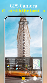
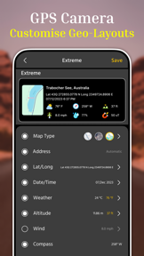
GPSCam is a photography utility for iOS that embeds real-time location, weather, and environmental sensor data onto images.
The App DNA
What makes this app unique?
Field professionals and trekkers use the app to create verifiable visual logs of site visits or expeditions, replacing manual note-taking with automated metadata stamping.
For Field professionals like civil engineers and architects, alongside outdoor enthusiasts and bloggers who require precise environmental data on their photos.
What does it look like?
Key features
Overlays technical metadata including altitude, wind speed, and magnetic field onto images.
Automates photo backup to Google Drive storage.
Embeds location, timestamp, and weather data directly onto photos at the moment of capture.
How much does it cost?
GPSCam is currently offered as a free utility with no visible subscription or IAP gates, limiting the revenue available to fund ongoing development.
Velocity
Dormant developmentopaqueShow more...
GPSCam has seen no development activity for 818 days. The app remains in a zombie state with no updates or feature additions since its initial launch. There is no evidence of ongoing maintenance or support for the platform.
Who built it?
Amiben Kevadiya
4 apps tracked · Business
 Trade Calculator, Stock Market
 Hora - Vedic Time Planner
 Video Player: All Media Player
User Sentiment
What do users think recently?
How are ratings & reviews evolving?
Not enough recent reviews to extract reliable themes yet.
Read the full review analysisCompetition
Competitive landscape for GPSCam : Live Geotag on Photos
How's the Business market?
GPSCam occupies a niche within the Business category, serving as a specialized documentation tool rather than a mass-market photography app. The lack of updates over the last 27 months signals a lack of competitive pressure or active market participation.
Read the market outlookThe rivals identified
Unlock the deeper market read.
Access the full report for freeThe Analyst's Read
Key takeaways for GPSCam : Live Geotag on Photos
Where is it heading?
The market for specialized field-documentation tools is shifting toward integrated, cloud-connected platforms that offer frequent feature updates. GPSCam's dormant status leaves it vulnerable to obsolescence as OS-level location and camera APIs evolve, signaling a likely decline in utility for professional users.
- The 27-month development silence indicates a lack of active maintenance, which increases the risk of technical failure on future iOS updates.
The SWOT
- Environmental data overlays provide technical documentation for civil engineering and site inspection workflows.
- Google Drive integration automates backup, reducing the risk of data loss for field professionals.
- Implementation of a subscription tier for professional-grade features could fund the development of advanced reporting tools for architects and inspectors.
Next best moves
Audit OS compatibility because the 27-month release gap risks breaking core functionality on newer iOS versions → maintain baseline utility.
The counter-intuitive read
The lack of monetization is not a missed opportunity but a structural barrier…
Read the full takeSince the last report: GPSCam has undergone no functional or pricing changes, remaining in a dormant state since May 2024. The primary shift is a more critical assessment of the app's long-term viability, now categorized as being in sunset mode.
Bottom line
GPSCam provides a specialized utility for site documentation, but the 27-month development silence suggests the product is effectively in sunset mode, leaving professional users exposed to future OS incompatibility risks.
Unlock 2 critical frictions, 1 market threat and the analyst’s take.
Access the full report for freeFAQ
Is GPSCam suitable for professional site documentation?
Does GPSCam require a subscription?
What are the alternatives to GPSCam for geotagging photos?
Sources
- [1] App Store, source
Report last updated