


Great Lakes HD Nautical Charts
By Flytomap




Great Lakes HD Nautical Charts is a navigation app for boaters and fishermen that provides offline nautical maps and community-sourced data on iOS.
The App DNA
What makes this app unique?
The app removes the dependency on cellular data for navigation, allowing users to access nautical charts in remote areas where mobile signal is unavailable.
For Boaters, fishermen, and outdoor enthusiasts who require professional-grade nautical mapping without the cost of dedicated marine plotters.
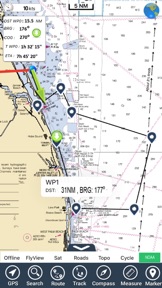
What does it look like?
Key features
Downloads full map coverage for use without cellular data or mobile signal.
Community-sourced data on marinas, anchorages, and hazards from over 200,000 boaters.
Provides localized data including wave height, wind speed, and tide information.
How much does it cost?
The $14.99 price point positions Great Lakes HD Nautical Charts as a low-cost alternative to expensive dedicated marine GPS hardware.
Velocity
Maintenance developmentperformanceShow more...
The app maintains a maintenance-level cadence, with only one release recorded in the analyzed window. The latest version focuses exclusively on device compatibility updates rather than new features or content. Development appears stable but limited to basic technical upkeep. No significant feature expansion has occurred in the last two months.
Who built it?
Flytomap
13+ apps tracked · Navigation
 Wind forecast for Windgurus
 Minnesota Lakes Fishing Charts
 Real Tides & Currents Graph HD
 Maine Lakes - GPS fishing maps
 USA Parks & Forests GPS Maps
 Flytomap All in One HD Charts
 Maldives GPS Map Navigator
 UK Parks & Forests GPS OS Maps
 Florida Nautical Charts GPS HD
 Mediterranean Sea GPS Charts
 AIS Maps: Marine & Lake charts
 Boating Greece HD GPS Charts
User Sentiment
What do users think recently?
Fresh user feedback skews frustrated. Users appreciate the simple map download process for tablets provides a straightforward way to access navigation data.
How are ratings & reviews evolving?
What users say, by theme
- The simple map download process for tablets provides a straightforward way to access navigation data
- The application fails to launch entirely following the latest update, preventing access to navigation features
3 of 3 recent reviews analyzed · limited sample
Read the full review analysisUnlock 1 more frustration theme, each backed by review evidence.
Access the full report for freeCompetition
Competitive landscape for Great Lakes HD Nautical Charts
How's the Navigation market?
Great Lakes HD Nautical Charts competes as a low-cost, offline-first alternative to marine plotters, anchored by a $14.99 one-time purchase price. The current 2.14-star rating across 7 total ratings highlights significant usability friction that limits its ability to capture market share from established hardware-integrated rivals.
Read the market outlookThe rivals identified
Unlock the deeper market read.
Access the full report for freeThe Analyst's Read
Key takeaways for Great Lakes HD Nautical Charts
Where is it heading?
The nautical mapping market is consolidating around apps that offer both offline reliability and high-precision rendering. Great Lakes HD Nautical Charts is currently exposed due to stability failures that prevent access to its core value proposition, which will accelerate churn if not addressed in the next release cycle.
- The latest update prevents the app from launching, which creates a critical churn risk for the user base.
- Restrictive zoom limits on charts hamper core navigation utility, leading to poor user experience despite the initial ease of map downloads.
The SWOT
- Offline map packs remove connectivity dependency
- ActiveCaptain integration provides community-verified navigation data
- Expand offline-first mapping to additional inland regions
Next best moves
Revert the latest update because it prevents the app from launching → restore core utility
+ 1 more prioritized moveThe counter-intuitive read
The app's offline-first design is a retention lever…
Read the full takeBottom line
Restoring launch stability is the immediate priority, as the current failure prevents access to the core navigation features that justify the $14.99 purchase. Addressing this will stabilize the user base, allowing the team to refine the zoom-level utility that currently limits navigation precision.
Unlock 2 critical frictions, 1 market threat, 1 more prioritized move and the analyst’s take.
Access the full report for freeFAQ
Is Great Lakes HD Nautical Charts worth paying for if I only boat occasionally?
Does Great Lakes HD Nautical Charts work without internet access?
What is the difference between this app and a dedicated marine GPS plotter?
Sources
- [1] App Store
Report last updated