


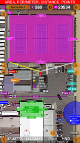


Planimeter 55 is a mapping utility designed for calculating distance, perimeter, and area on satellite or hybrid maps. It enables users to manage spatial data by adding annotated points, photos, and audio recordings to specific locations. The app is notable for its real-time calculation engine that provides measurements as the user navigates the map.
Overview · Full Intel report in progress
The App DNA
What makes this app unique?
For Professionals and property owners requiring precise spatial measurements for construction, landscaping, and land management tasks.
What does it look like?
Key features
Instantly calculates area, distance, and adjacent line lengths while moving across the map.
Utilizes native Google Maps support to provide high-detail satellite and hybrid map views.
Allows users to mark locations with custom colors, text notes, audio recordings, and geo-tagged images.
Supports seamless sharing and exporting of measured projects for external use.
How much does it cost?
Velocity
Steady developmentShow more...
5 versions in history. Development pace: steady.
Who built it?
Kalimex-Consulting s.r.o. @Blocoware & Stanislav Dvoychenko
5 apps tracked · Navigation
 GPS Camera 55. Field Survey
 Compass 55. Map & GPS kit.
 Taximeter. GPS taxi cab meter.
 GPS Team 55
User Sentiment
What do users think recently?
How are ratings & reviews evolving?
Not enough recent reviews to extract reliable themes yet.
Read the full review analysisCompetition
Competitive landscape for Planimeter 55. Measure on map.
How's the Navigation market?
The rivals identified
The Analyst's Read
Key takeaways for Planimeter 55. Measure on map.
Where is it heading?
Bottom line
While the app offers robust measurement tools, users report that stability is significantly improved by utilizing the Google Maps integration over default map settings.
Report last updated