


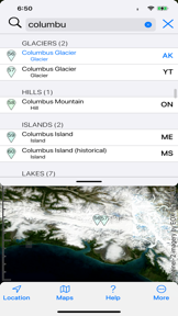
Topo Maps 2 provides offline topographic and satellite mapping for the US and Canada, utilizing data from the USGS, US Forest Service, and Natural Resources Canada. The app enables users to record tracks, plot routes in 3D, and visualize terrain through hybrid and panorama modes. It is notable for its focus on historical geographic data and offline functionality for outdoor navigation.
Overview · Full Intel report in progress
The App DNA
What makes this app unique?
For Outdoor enthusiasts, hikers, and field researchers requiring reliable offline navigation and historical terrain data.
What does it look like?
Key features
Provides access to topographic and satellite imagery without requiring a network connection once maps are installed.
Allows users to record tracks, draw routes, and export GPX files for use with other devices.
Features a 3D fly-along mode for routes and a panorama mode to display visible terrain silhouettes.
Supports the display of geolocated photos directly on the map interface.
How much does it cost?
Velocity
Intense developmentShow more...
5 versions in history. Development pace: intense.
Who built it?
Mappendix
5 apps tracked · Navigation
 3D Map New Zealand
 UK Map
 Topo Maps
 Topo Maps for iPad
User Sentiment
What do users think recently?
How are ratings & reviews evolving?
Not enough recent reviews to extract reliable themes yet.
Read the full review analysisCompetition
Competitive landscape for Topo Maps 2
How's the Navigation market?
The rivals identified
The Analyst's Read
Key takeaways for Topo Maps 2
Where is it heading?
Bottom line
While the app offers robust offline mapping and historical data, users have expressed concerns regarding the transition to a subscription model and the efficiency of the map download process.
Report last updated