


Apostolos Samaras
For safety-conscious users and vehicle owners requiring real-time monitoring of environmental conditions or hardware status.
 myLocation - GPS Coordinates




Snapshot
Who is Apostolos Samaras?
Developing hardware-integrated utility tools for real-time environmental monitoring and vehicle safety.
Target audience


Portfolio
Free 3Last updated

myLocation - GPS Coordinates
v1.34
1.1y ago
Publisher DNA
What defines Apostolos Samaras?
Publisher DNA
Primary focus
Hardware-integrated safety and utility tools
Scale
indie
Target audience
Safety-conscious users and vehicle owners requiring real-time monitoring of environmental conditions or hardware status.
Portfolio momentum
Maintained a steady cadence with 3 updates in the last 6 months and a new product launch in early 2026.
Portfolio
What does Apostolos Samaras ship?
Apps
5 apps analysed


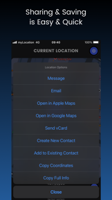
GPS Coordinates app to get, share, save, search and convert coordinates.


Live Monitor-real-time monitor battery status with auto notifications.


Telegram/Email alert integration provides remote safety utility
- Reliable power failure detection provides peace of mind for users monitoring critical home infrastructure
- Excessive alert volume creates significant noise pollution and distress for users and their neighbors

Single-market publisher, every app ships only to United States.
Based on 3 of 5 apps with localized market data, more coverage rolling in as scans complete · last scanned .
Americas (1)
- United States3 / 3
Core markets (3/3 apps)
User Sentiment
How do users feel about their apps?
0
Positive apps
0
Neutral / mixed
1
Negative apps
30/100
Avg sentiment score
Rivals
Who does Apostolos Samaras compete with?
The rivals identified
Nemeses(1)


Compass & GPS targets the same outdoor navigation audience as iTools, but captures a larger user base through a free pricing model and specialized solar tracking features.
Contenders(2)


Both applications target outdoor navigation and travel, competing for the same user base seeking location-based tools for hiking, boating, and travel.


Both apps target outdoor navigation users, with iTools providing general travel metrics and the rival offering specialized religious navigation tools.
Same space(29)


This app serves the same earthquake monitoring audience but provides global data aggregation from USGS and EMSC, which contrasts with the local hardware-based detection of the source app.


This app provides network-based location data that complements the physical location tools found in iTools.


This app targets the same disaster-preparedness segment by providing official alerts for the severe weather events that trigger power outages.


This app targets the same earthquake monitoring demographic by combining official data with community verification.


This app provides broader meteorological context for users who need to plan around the weather events that often cause power outages.


It complements the source app by providing orientation and navigation tools that outdoor users often require alongside environmental monitoring.


While iTools focuses on physical location, this app provides network-based location forensics for IT professionals.


This app provides a focused navigation experience that competes with the orientation tools found in the iTools dashboard.


This app offers a minimalist alternative to the navigation features in iTools, prioritizing a simplified interface over the multi-tool approach.


It shares the utility-focused nature of iTools by using device sensors for physical measurement, though it focuses on leveling rather than navigation.


This app provides a professional-grade alternative to the seismometer feature in iTools, including data export capabilities.


This app attempts to provide location-based utility similar to iTools, though it is currently hindered by technical obsolescence.


This pre-installed utility competes with the iTools navigation dashboard by offering system-level integration that third-party apps cannot match.


It serves the same safety-conscious user base by providing real-time environmental tracking, specifically for hurricane-prone regions.


It occupies the same utility-focused space for environmental alerts, though it targets precipitation rather than seismic activity.


This app provides a navigation dashboard that mirrors the functionality of iTools with a focus on aesthetic themes.


This app serves as a specialized vibration monitor that competes with the seismic features of iTools by using the Mercalli scale.


This app competes directly in the seismic monitoring category by offering global data aggregation and crowdsourced reporting.


It overlaps with the iTools navigation dashboard by providing speed and elevation tracking, but adds trip logging and HUD capabilities.


This app offers a basic navigation utility that competes with the iTools dashboard for offline speed and distance tracking.


This app competes with the iTools navigation dashboard by offering trip analytics and multiple display modes for drivers.


This app serves as a more specialized alternative to the earthquake alarm feature in iTools by aggregating data from over 30 global sources.


This app targets the same driver demographic as iTools but captures a larger user base through a free, specialized GPS Black box incident logging feature.


It shares the earthquake early warning focus but relies on government-backed infrastructure rather than local device sensors.


It provides a more granular version of the seismometer feature found in iTools, focusing on vibration analysis rather than emergency alarms.


This app functions as a direct alternative to the navigation dashboard in iTools, specifically for iPhone-based speed monitoring.


This app provides route planning and location search features that complement the navigation dashboard in iTools.


This app provides location-based navigation tools that overlap with the core location utility of iTools.


This app expands on the earthquake monitoring feature of iTools by adding community reporting and risk assessments.
New entrants(2)


This app occupies the same home-screen utility space by combining weather forecasting with a daily alarm clock for routine planning.


It serves as a secondary utility for weather information, similar to how users might keep the source app for environmental awareness.
Frequently asked questions
How many apps does Apostolos Samaras publish?
What kind of apps does Apostolos Samaras make?
What is Apostolos Samaras's top app?
In how many countries are Apostolos Samaras's apps available?
What fed this analysis
- Apps analyzed:
- 4
- With full intel:
- 0
- With overview:
- 4
- Website scraped:
- yes
- Social presence:
- no
