Good To Forecast
 UAV Forecast for Drone Pilots


Publisher DNA
What defines Good To Forecast?
AI intelligence is not yet available for Good To Forecast. The portfolio data below is up to date.
Portfolio
What does Good To Forecast ship?
Apps
2 apps analysed

Analysis in progress
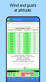
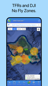
Weather for drones: winds aloft, GPS, Kp index, No-Fly Zones and TFRs


Configurable safety thresholds allow drone operators to customize alerts based on their specific hardware limits
- Drone pilots rely on the accurate weather and wind speed data for safe flight planning
- Aggressive paywall implementation restricts all core functionality and prevents users from accessing basic weather data
Single-market publisher, every app ships only to United States.
Based on 1 of 2 apps with localized market data, more coverage rolling in as scans complete · last scanned .
Americas (1)
- United States1 / 1
Core markets (1/1 apps)
User Sentiment
How do users feel about their apps?
0
Positive apps
0
Neutral / mixed
1
Negative apps
35/100
Avg sentiment score
Rivals
Who does Good To Forecast compete with?
The rivals identified
Nemeses(2)

Both apps target outdoor enthusiasts who require precise, location-specific wind data for safety, leading to direct competition for users who prioritize weather accuracy for flight or water-based activities.


Both apps target outdoor users requiring precise wind and weather conditions, creating direct competition for the drone pilot segment that prioritizes wind speed for flight safety.
Contenders(9)


AURA targets the same drone pilot demographic as UAV Forecast by providing overlapping flight safety metrics like wind, satellite data, and no-fly zone alerts.


Both apps serve outdoor enthusiasts who rely on specialized atmospheric and solar data to plan activities. They compete for the same user segment interested in hyperlocal environmental conditions.


Both apps serve professional and enthusiast users requiring hyperlocal, high-fidelity environmental data for safety-critical navigation, creating a direct overlap in the specialized weather utility segment.


Both apps serve outdoor enthusiasts requiring precise, location-specific environmental data for safety-critical planning. They compete for the attention of users who prioritize site-specific weather conditions before engaging in outdoor activities.


Both apps compete for the same outdoor-planning user base by providing localized weather data, though they diverge on target utility between drone safety and general commuting.


Both apps compete for user attention during outdoor activity planning, as drone pilots often consult general weather radar to assess baseline conditions before checking aviation-specific flight safety data.


Both apps target outdoor professionals and enthusiasts requiring precise meteorological data, though they diverge between drone-specific safety planning and general weather visualization.


Both apps target outdoor users requiring hyper-local wind data, but WindAlert captures the casual hobbyist segment that UAV Forecast currently alienates with its subscription-only model.


Both apps target aviation and outdoor enthusiasts with high-resolution meteorological data, creating direct competition for the same professional and hobbyist pilot user base.
Same space(33)


Offers offline weather data for pilots operating in remote areas without constant internet connectivity.


This app shares the same core utility of environmental monitoring for specific outdoor activities, targeting enthusiasts who need location-based visibility data.


This app serves as a direct competitor by combining airspace tools and weather forecasting into a single flight-planning workflow.


Offers real-time rain tracking for pilots planning flights during changing weather conditions.


Acts as a generic weather data source for pilots needing basic environmental conditions.


This app focuses on the safety and community aspects of drone flying, which complements the technical forecasting found in UAV Forecast.


Provides storm tracking for pilots who need to monitor hurricane or severe weather paths.


This app functions as a professional-grade alternative for pilots who require comprehensive flight planning and weather visualization tools.


This app is a direct functional alternative that provides altitude-specific wind data, which is a critical safety metric for drone pilots.


Provides essential marine weather data for pilots operating drones over coastal or maritime environments.


This app serves as a parallel utility for hobbyists who require high-resolution environmental data, mirroring the data-driven approach of drone flight planning.


Supplies health and environmental indices for pilots assessing general flight suitability.


Offers detailed weather maps for pilots tracking specific meteorological variables like wind gusts and pressure.


This app provides aviation-grade weather data that overlaps with the technical requirements for safe drone flight planning.


Offers visual weather curves for pilots who need to interpret daily temperature and wind trends.


This app uses similar solar and weather data inputs to provide specialized environmental analysis for a specific user base.


Provides high-precision data for professional pilots requiring accuracy for aviation-related tasks.


Offers direct radar data for pilots needing to see rain intensity before launching a drone.


Acts as a centralized weather platform for pilots who prefer cross-platform synchronization of their locations.


Provides high-fidelity satellite imagery for pilots needing visual confirmation of cloud cover and storm systems.


This app provides a similar combination of environmental and regulatory data to help pilots maintain safe flight operations.


This app provides a comprehensive suite of drone-specific safety tools that directly overlap with the core functionality of UAV Forecast.


This app provides specialized monitoring for GPS and geomagnetic activity, which is essential for maintaining drone flight stability.


Delivers severe weather notifications for pilots needing to avoid hazardous flight conditions.


Provides specialized wave and wind data for pilots operating drones near surf zones.


This app competes for the same user attention by providing specialized, high-fidelity environmental forecasting that requires precise location data.


Serves as a general planning tool for pilots who need hourly granularity for their daily work.


Provides basic weather tracking for pilots who do not require specialized drone-specific safety thresholds.


This app offers a similar data-rich interface for hobbyists who need to monitor technical environmental metrics for their activities.


Supplies comprehensive weather observations for pilots needing data on atmospheric pressure and visibility.


Provides general meteorological context for pilots who need broader weather data beyond drone-specific metrics.


Provides basic weather updates for pilots needing quick environmental checks.


Serves as a general-purpose weather tool for pilots who need standard meteorological data alongside radar.
New entrants(3)


Offers basic weather monitoring for pilots needing quick checks on wind speed and precipitation.


Provides hourly forecast data for pilots planning their daily flight schedules.


This app provides general weather forecasting that serves as a baseline for any outdoor activity, including drone flight.