




iSailGPS is a navigation tool that provides offline access to USA NOAA Raster Nautical Charts for iPhone and iPad users. It functions as a standalone GPS receiver, allowing sailors to record tracks, manage waypoints, and create routes without requiring a cellular signal. The app distinguishes itself by offering a one-time purchase model with no recurring subscriptions or in-app advertisements.
Overview · Full Intel report in progress
The App DNA
What makes this app unique?
For Recreational sailors and boaters requiring reliable, offline marine navigation tools.
What does it look like?
Key features
Provides offline access to official USA nautical charts for navigation in areas without cellular coverage.
Records sailing tracks in the background and allows for the creation of waypoints and routes.
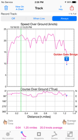
Visualizes real-time navigation data to assist in monitoring vessel performance and trajectory.
Enables precise waypoint marking via geotagged photos, addresses, or projection from known coordinates.
How much does it cost?
Velocity
Steady developmentShow more...
5 versions in history. Development pace: steady.
Who built it?
James Associates
4 apps tracked · Navigation
 iHikeGPS : Classic Topo Maps
 iHikeGPS NZ : LINZ Topo Maps
 iSailGPS NZ : Nautical Charts
User Sentiment
What do users think recently?
How are ratings & reviews evolving?
Not enough recent reviews to extract reliable themes yet.
Read the full review analysisCompetition
Competitive landscape for iSailGPS : NOAA USA RNC Charts
How's the Navigation market?
The rivals identified

By Nobeltec, Inc.
Both apps target coastal sailors and boaters with offline-first marine navigation, creating direct competition for users seeking reliable chart access without cellular dependency.
- TZ iBoat integrates high-resolution bathymetry and satellite data, while iSailGPS relies on standard NOAA Raster Nautical Charts.
- TZ iBoat supports external radar and AIS hardware integration, whereas iSailGPS functions as a standalone GPS receiver.
- TZ iBoat utilizes a freemium subscription model, while iSailGPS maintains a one-time purchase price of 7.99 dollars.
 Navionics® BoatingContender
 Orca: Boat GPS, Charts, RoutesContender
 Nautical Charts & MapsContender
 Wärtsilä iSailorContender
 B&G: Companion App for SailorsContender
 iNavX: Marine NavigationContender
 i-Boating: Marine Charts & GpsContender
 PRO CHARTS - Marine NavigationContender
Show 2 more


Unlock the head-to-head verdict: where this rival wins, and where it loses.
Access the full report for freeThe Analyst's Read
Key takeaways for iSailGPS : NOAA USA RNC Charts
Where is it heading?
Bottom line
iSailGPS offers a subscription-free, offline-capable navigation solution, though some users report challenges with manual chart management during active transit.
Report last updated