


Hunt Mountain Software
For geologists, field researchers, and outdoor enthusiasts requiring precise location data and stratigraphic reference tools.
 Coordinates


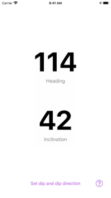


Snapshot
Who is Hunt Mountain Software?
Providing specialized geological and navigation tools for field researchers and outdoor professionals. Bridging the gap between academic science and mobile utility.
Target audience


Portfolio
Free 7Last updated

Coordinates
v6.52
7mo ago
Publisher DNA
What defines Hunt Mountain Software?
Publisher DNA
Primary focus
Geological and navigation utility tools
Scale
indie
Target audience
Geologists, field researchers, and outdoor enthusiasts requiring precise location data and stratigraphic reference tools.
Origin
Founded in 2008 by Steven Holland, a professor in geology and marine sciences, to develop affordable software for the natural sciences.
Signature Patterns
- •Strong focus on niche scientific and field-work utilities
- •Integration of GPS and mapping data across navigation titles
- •Monetization split between free utility tools and paid specialized reference apps
- •Direct alignment with academic and professional geological workflows
Portfolio momentum
Released 3 updates across 9 apps in the last 6 months, with the most recent major release occurring 7 days ago.
Company profile
medium confidence- Founded
- 2008
Portfolio
What does Hunt Mountain Software ship?
Apps
9 apps analysed


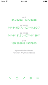


- Precise coordinate mapping functionality provides essential utility for professional cell tower location tasks

Single-market publisher, every app ships only to United States.
Based on 1 of 9 apps with localized market data, more coverage rolling in as scans complete · last scanned .
Americas (1)
- United States1 / 1
Core markets (1/1 apps)
User Sentiment
How do users feel about their apps?
1
Positive apps
0
Neutral / mixed
0
Negative apps
90/100
Avg sentiment score
Rivals
Who does Hunt Mountain Software compete with?
The rivals identified
Nemeses(3)


Both apps target users interested in geological data, but they serve distinct workflows: Strike and Dip focuses on active field measurement, while Backseat Geologist provides passive audio interpretation of geologic units.


Digger's Map competes for the same geology enthusiast audience by offering map-based discovery of geological sites, overlapping with the core utility of Mancos.


Dominates the outdoor navigation space with a comprehensive feature set that dwarfs the target's simple conversion utility.
Contenders(10)


Enables citizen science for fossil research, creating a network for amateur and professional paleontologists.


Directly targets the coordinate-heavy user base with specialized topographic visualization tools.


Both apps target geology enthusiasts and fossil hunters with map-based geological data, creating direct competition for field utility.


G-Spyke targets the same geology research audience by providing specialized tools for stratigraphic data collection and field-based geological documentation.


Both apps target geology enthusiasts and field professionals, with Geology Toolkit providing AI-driven identification while Mancos focuses on stratigraphic data and fossil collection mapping.


Both apps target the geology enthusiast segment, with Mancos providing spatial mapping tools while the rival provides a reference dictionary for terminology.


Both apps target the geological field data collection market, competing for the same user base of researchers and enthusiasts through map-centric interfaces.


Both apps target geological field researchers, but they diverge in utility: Mancos provides map-based stratigraphic data while StraboTools performs quantitative photo analysis of rock fabric.


Both apps target geology enthusiasts and researchers with stratigraphic and mapping data, creating direct competition for field-use utility.


Both apps target the stratigraphic and geological data space, competing for the attention of researchers and geology enthusiasts who require access to geological formations and timescale records.
Same space(39)

Provides interactive trivia, serving as a study tool for users interested in Earth science concepts.


Provides advanced land area and perimeter measurement tools that supplement the structural mapping capabilities of geologists.


Operates in the broader outdoor activity space, focusing on community-driven trail discovery rather than coordinate utility.


Serves as a primary mapping alternative for field professionals who require offline access to custom map imports.


Provides a professional-grade GIS mapping suite that overlaps with coordinate management but targets enterprise users.


Acts as a simple, aesthetic orientation tool for users who need quick heading data alongside their primary field transit.


Provides a specialized GPS camera for verifiable photo documentation, serving the same professional field reporting segment.


Directly competes with the geological measurement suite by offering professional-grade AR viewfinder and inclinometer tools.


Acts as a legacy orientation tool for basic directional heading and degree measurement in the field.


Functions as a minimalist orientation utility for users who prefer a clutter-free interface for basic heading checks.


Provides comprehensive paleontology education, serving as a reference tool for Earth's history.


Provides offline access to geological data, serving field professionals in remote locations.


Offers trivia for fossil and Earth history, serving as an educational study tool.


Provides high-visibility directional data for users who need simple, readable orientation during field activities.


Visualizes global climate data, providing environmental context for users interested in Earth science.


Offers historical map overlays, providing context for geographical changes over time.


Explains Earth science concepts through interactive animations, serving as a supplemental educational resource.


Provides basic magnetic and true north orientation for users needing simple, device-based navigation.


Functions as a field companion for outdoor navigation, overlapping with the GPS-based exploration features of Mancos.


Offers global accuracy for magnetic and true north, providing a reliable alternative for field orientation.


Offers a specialized prayer compass alongside standard orientation tools for diverse field navigation needs.


Provides a specialized digital sextant for maritime geologists or researchers needing celestial position calculations.


Serves professional GIS users who require robust data collection tools rather than simple coordinate format conversion.


Provides geological mapping for Poland, serving as a regional utility for Earth science data.


Offers granular location data and What3Words integration that complements the structural measurement workflow of geologists.


Maps soil properties and landscapes, providing granular geological data similar to the stratigraphic focus of Mancos.


Provides specialized USGS-sourced geological data for identifying mineral resource sites.


Visualizes global weather patterns, serving users who track environmental conditions alongside geological data.


Simulates Earth's geological history, providing a 3D perspective on tectonic and climate changes.


Provides a gyroscope-enhanced bearing tool for field users needing to freeze data for easier recording.


Provides basic cardinal direction and altitude data that overlaps with the core navigation needs of field researchers.


Assists in fossil identification, directly complementing the fossil collection features of Mancos.


Focuses on exam preparation, serving students who need structured review of Earth science topics.


Users report: Offers interactive science education for children, targeting a younger demographic than the professional focus of Mancos.


Tracks tectonic shifts and environmental history, providing a temporal dimension to geological data.


Supports high-precision measurement requirements through external hardware, serving professional field workers.


Provides a high-visibility, large-format directional tool for field users requiring quick, readable orientation.


Provides interactive simulations of geological forces, serving as an educational alternative to professional mapping tools.


Tracks natural events, providing real-time environmental data for users interested in Earth monitoring.
New entrants(1)


Combines live earth views and GPS tools, serving as a broader navigation companion for field scouting.
The Analyst's Read
The bottom line on Hunt Mountain Software
Bottom line
Hunt Mountain Software is a disciplined, founder-led studio that successfully monetizes niche scientific expertise through high-utility mobile tools. Their ability to maintain a 5.0 rating on specialized educational apps suggests strong product-market fit within the geology community.
Frequently asked questions
How many apps does Hunt Mountain Software publish?
What kind of apps does Hunt Mountain Software make?
What is Hunt Mountain Software's top app?
In how many countries are Hunt Mountain Software's apps available?
What fed this analysis
- Apps analyzed:
- 9
- With full intel:
- 0
- With overview:
- 9
- Website scraped:
- yes
- Social presence:
- yes
